Difference between revisions of "Cunninghame"
From Wikishire
| (One intermediate revision by the same user not shown) | |||
| Line 1: | Line 1: | ||
| + | [[File:Cunninghame - Ayrshire.svg|thumb|250px|Kyle in Ayrshire]] | ||
[[File:Blaeu - Atlas of Scotland 1654 - CVNINGHAMIA - Cunningham.jpg|right|thumb|300px|Cunninghame in Blaeu's Atlas (1654)]] | [[File:Blaeu - Atlas of Scotland 1654 - CVNINGHAMIA - Cunningham.jpg|right|thumb|300px|Cunninghame in Blaeu's Atlas (1654)]] | ||
{{county|Ayrshire}} | {{county|Ayrshire}} | ||
| Line 5: | Line 6: | ||
Ayrshire is divided naturally by its three primary rivers all running in a generally westward direction to flow into the firth of Clyde: The [[River Irvine]] forms the southern boundary of Cunninghame, south of which is [[Kyle]]. | Ayrshire is divided naturally by its three primary rivers all running in a generally westward direction to flow into the firth of Clyde: The [[River Irvine]] forms the southern boundary of Cunninghame, south of which is [[Kyle]]. | ||
| − | + | Cunninghame comprises the parishes of:<ref>[http://www.visionofbritain.org.uk/descriptions/entry_page.jsp?text_id=102210 Frances Groome, ''Ordnance Gazetteer of Scotland'', 1882-4, (Vision of Britain)]</ref> | |
| − | {| | + | {{div col|3}} |
| − | + | ||
| − | + | ||
*[[Ardrossan]] | *[[Ardrossan]] | ||
| − | *[[Beith]] (part) | + | *[[Beith]] (part)<sup>*</sup> |
*[[Dalry, Ayrshire|Dalry]] | *[[Dalry, Ayrshire|Dalry]] | ||
*[[Dreghorn]] | *[[Dreghorn]] | ||
| + | *[[Dunlop]] (part)<sup>*</sup> | ||
*[[Fenwick, Ayrshire|Fenwick]] | *[[Fenwick, Ayrshire|Fenwick]] | ||
*[[Irvine]] | *[[Irvine]] | ||
*[[Kilbirnie]] | *[[Kilbirnie]] | ||
| − | |||
| − | |||
*[[Kilmarnock]] | *[[Kilmarnock]] | ||
*[[Kilmaurs]] | *[[Kilmaurs]] | ||
| Line 26: | Line 24: | ||
*[[Stevenston]] | *[[Stevenston]] | ||
*[[Stewarton]] | *[[Stewarton]] | ||
| − | *[[ | + | *[[West Kilbride]] |
| − | + | {{div col end}} | |
| + | <sup>*</sup>: Extends into Renfrewshire. | ||
==Outside links== | ==Outside links== | ||
| Line 37: | Line 36: | ||
{{reflist}} | {{reflist}} | ||
| − | + | {{Ayrshire districts}} | |
Latest revision as of 16:24, 23 May 2020
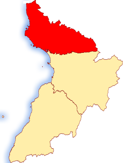
Cunninghame is the northern part of Ayrshire; one of the three traditional divisions of the county. It is the most populous of the three, with 188,832 residents as of 2011.
Ayrshire is divided naturally by its three primary rivers all running in a generally westward direction to flow into the firth of Clyde: The River Irvine forms the southern boundary of Cunninghame, south of which is Kyle.
Cunninghame comprises the parishes of:[1]
*: Extends into Renfrewshire.
Outside links
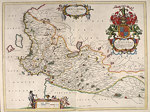
- Blaeu Atlas of Scotland, 1654
- Counties of Scotland, 1580-1928
- John Thomson's Atlas of Scotland, 1832
References
| Districts of Ayrshire |
|---|

