County Clare
From Wikishire
Revision as of 22:48, 4 August 2010 by RB (Talk | contribs) (Created page with '{{Infobox county |name=County Clare |irish=Contae an Chláir |map image=Island of Ireland location map Clare.svg |picture=Poulnabrone dolmen-SteveFE.jpg |picture caption=Poulnabr…')
| County Clare Irish: Contae an Chláir Republic of Ireland | |
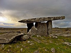
 Poulnabrone dolmen, the Burren | |
|---|---|

| |
| [Interactive map] | |
| Province: | Munster |
| Area: | 1,330 square miles |
| Population: | 117,196 |
| County seat: | Ennis |
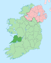
County Clare is a county on Ireland's west coast, a triangular county between the mouth of the Shannon and Galway Bay. It is the northernmost county of Munster, and the only part of that province lying north of the Shannon.
The most distinctive feature of County Clare is the Burren, a bleak, barren rocky land in stark contrast to the green of the rest of the county.
This county article is a stub: help to improve Wikishire by building it up.
| Counties of the Republic of Ireland |
|---|
|
Carlow • Cavan • Clare • Cork • Donegal • Dublin • Galway • Kerry • Kildare • Kilkenny • Laois • Leitrim • Limerick • Longford • Louth • Mayo • Meath • Monaghan • Offaly • Roscommon • Sligo • Tipperary • Waterford • Westmeath • Wexford • Wicklow |