Caputh
From Wikishire
Revision as of 10:43, 5 October 2015 by Owain (Talk | contribs) (Created page with "{{infobox town |county=Perthshire |gaelic= a' Cheapaich |picture=Caputh.jpg |picture caption=Caputh village in the Winter |os_grid_reference= NO088400 |latitude=56.543115 |lo...")
| Caputh Gaelic: a' Cheapaich | |
| Perthshire | |
|---|---|
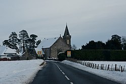
 Caputh village in the Winter | |
| Location | |
| Location: | 56°32’35"N, 3°29’5"W |
| Data | |
| Post town: | Blairgowrie |
| Postcode: | PH13 |
| Dialling code: | 01828 |
| Local Government | |
| Parliamentary constituency: |
Perth and North Perthshire |
Caputh is a village and parish in Perthshire. The village lies on the A984 Coupar Angus to Dunkeld road about six miles east of Dunkeld and eight miles west of Coupar Angus.[1] The ancient parish lies in nine separate parts. The main body lies to the east of Dunkeld and encompasses its eastern parts. The detached parts (with Ordnance Survey naming) are:
- Det. 1: 0.016 acres locally situate in the parish of Longforgan. A very small triangular part on the county boundary.[2]
- Det. 2: 285 acres locally situate in the parish of Auchterhouse, Angus.
- Det. 3: 237 acres locally situate in the parish of Collace.
- Det. 4: 693 acres locally situate in the parish of Kirkmichael.
- Det. 5: 282 acres locally situate in the parish of Kinnettles, Angus. This part also forms a detached part of Perthshire.
- Det. 6: 414 acres locally situate in the parish of Clunie.
- Det. 7: 310 acres locally situate in the parish of Kinloch.
- Broughty Castle, locally situate in the parish of Monifieth, Angus. This part also forms a detached part of Perthshire.
References
- ↑ "Blairgowrie & Forest of Alyth", Ordnance Survey Landranger Map, 2008, ISBN 0-319-23121-6
- ↑ Perth and Clackmannan Perthshire Sheet LXXXVIII.2, http://maps.nls.uk/view/74479241
This Perthshire article is a stub: help to improve Wikishire by building it up.