Difference between revisions of "Black Coast"
(Created page with "{{territory|BAT}} '''Black Coast''' is the portion of the east coast of Palmer Land within the British Antarctic Territory, between Cape Boggs and Cape Mackintos...") |
|||
| (One intermediate revision by the same user not shown) | |||
| Line 1: | Line 1: | ||
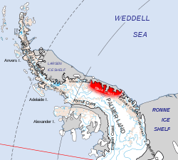
| + | [[File:Black Coast.svg|right|thumb|250px|Location of the Black Coast]] | ||
{{territory|BAT}} | {{territory|BAT}} | ||
'''Black Coast''' is the portion of the east coast of [[Palmer Land]] within the [[British Antarctic Territory]], between [[Cape Boggs]] and [[Cape Mackintosh]]. This coast was discovered and photographed from the air by members of the East Base of the U.S. Antarctic Service, 1939–41, on a flight of 30 December 1940 and roughly surveyed from the ground by the United States Antarctic Service. The most southerly point reached by the air survey was [[Wright Inlet]] at 74°S, but features as far south as [[Bowman Peninsula]] are identifiable in the aerial photographs taken on the flight. | '''Black Coast''' is the portion of the east coast of [[Palmer Land]] within the [[British Antarctic Territory]], between [[Cape Boggs]] and [[Cape Mackintosh]]. This coast was discovered and photographed from the air by members of the East Base of the U.S. Antarctic Service, 1939–41, on a flight of 30 December 1940 and roughly surveyed from the ground by the United States Antarctic Service. The most southerly point reached by the air survey was [[Wright Inlet]] at 74°S, but features as far south as [[Bowman Peninsula]] are identifiable in the aerial photographs taken on the flight. | ||
| Line 11: | Line 12: | ||
==References== | ==References== | ||
*{{basgaz}} | *{{basgaz}} | ||
| + | |||
| + | {{BAT coasts}} | ||
{{Catself}} | {{Catself}} | ||
[[Category:Coasts of Palmer Land]] | [[Category:Coasts of Palmer Land]] | ||
Latest revision as of 20:49, 19 July 2020
Black Coast is the portion of the east coast of Palmer Land within the British Antarctic Territory, between Cape Boggs and Cape Mackintosh. This coast was discovered and photographed from the air by members of the East Base of the U.S. Antarctic Service, 1939–41, on a flight of 30 December 1940 and roughly surveyed from the ground by the United States Antarctic Service. The most southerly point reached by the air survey was Wright Inlet at 74°S, but features as far south as Bowman Peninsula are identifiable in the aerial photographs taken on the flight.
Black Coast was named after Commander (later Admiral) Richard B. Black, U.S. Navy Reserve (1902–92), leader of the December 30 flight and commanding officer of the East Base, surveyor with Second Byrd Antarctic Expedition, 1933-35, and member of ODF, 1955-56
The coast was further surveyed by the Falkland Islands Dependencies Survey-Ronne Antarctic Research Expedition from "Stonington Island", 1947-48.
Location
- Location map: 71°36’46"S, 61°8’57"W
References
- Gazetteer and Map of The British Antarctic Territory: Black Coast
| Coasts of the British Antarctic Territory | |||
|---|---|---|---|
| Trinity Peninsula |
Graham Land: Nordenskjöld • Oscar II • Foyn • Bowman • Palmer Land: Wilkins • Black • Lassiter • Orville • Zumberge |
||
|
Graham Land: Davis • Danco • Graham • Loubet • Fallières • Palmer Land: Rymill • English |
|||
