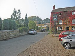
Knossington
| Knossington | |
| Hertfordshire | |
|---|---|
 Knossington | |
| Location | |
| Grid reference: | SK801086 |
| Location: | 52°40’8"N, -0°48’54"W |
| Data | |
| Post town: | Melton Mowbray |
| Postcode: | LE15 |
| Dialling code: | 01664 |
| Local Government | |
| Council: | Melton |
| Parliamentary constituency: |
Melton |
Knossington is a village and parish in the east of Leicestershire, close to the border with Rutland. It lies between the village of Somerby and Oakham.
The whole village has been a designated Conservation area since 1977[1].
History and notable buildings
Knossington is listed in the Domesday Book, having 31 households[2], in the hundred of Gartree.
In the south of the village is the Manor House, dating from the 16th or early 17th century[3].
The west side of the village is dominated by the grounds of Knossington Grange[4], a large Tudor style mansion built in the late 19th century, now a school[5].

References
- ↑ Melton council. "Knossington CA Appraisal". http://www.melton.gov.uk/docs/Knossington%20CA%20Appraisal.doc. Retrieved 4 Jun 2012.
- ↑ Domesday Book online. "Knossington - Domesday Book". http://domesdaymap.co.uk/place/SK8008/knossington/. Retrieved 4 Jun 2012.
- ↑ Knossington (History of the County of Leicestershire)
- ↑ British Listed Buildings. "Knossington Grange". http://www.britishlistedbuildings.co.uk/en-189872-knossington-grange-knossington-and-cold-. Retrieved 4 Jun 2012.
- ↑ "The Grange Theraputic School". http://www.knossingtongrange.co.uk. Retrieved 4 Jun 2012.