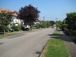
Eastbury, Hertfordshire
Eastbury, Hertfordshire
| Eastbury | |
| Hertfordshire | |
|---|---|
 Eastbury Road, Eastbury | |
| Location | |
| Grid reference: | TQ094928 |
| Location: | 51°37’24"N, 0°25’9"W |
| Data | |
| Post town: | Northwood |
| Postcode: | HA6 |
| Dialling code: | 01923 |
| Local Government | |
| Council: | Three Rivers |
| Parliamentary constituency: |
South West Hertfordshire |
Eastbury is a town in south-western Hertfordshire, adjacent to the Middlesex border and the Middlesex town of Northwood. The division between the two towns and counties is marked by a remarkable footpath running for several miles along the county border, cutting through cross-border developments.
Other places nearby include Moor Park and South Oxhey; Eastbury is about equal distance between the Northwood and Moor Park tube stations (both on the London Underground Metropolitan Line). Northwood Headquarters is in fact in Eastbury.