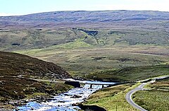
Birkdale Footbridge
| Birkdale Footbridge | |
| County Durham, Westmorland | |
|---|---|

| |
| Location | |
| Type: | Concrete bean |
| Carrying: | Track and footpath |
| Crossing: | River Tees |
| Location | |
| Grid reference: | NY81412876 |
| Location: | 54°39’13"N, 2°17’23"W |
| Structure | |
| Type: | Concrete bean |
| History | |
| Built 1966 | |
| Information | |
The Birkdale Footbridge is a concrete bridge in the Pennines, crossing the infant River Tees, immediately above the stunning cascade of Cauldron Snout.
The bridge carries a private service road for the Cow Green Reservoir and is also used by the Pennine Way. Here the river marks the border of County Durham with Westmorland, and so this short bridge joins the two counties: the Tees meets the border of the North Riding of Yorkshire a few hundred yards below, where the Maize Beck joins the Tees. It is just downstream of the dam of Cow Green Reservoir, and yards below the bridge begin the thrashing waters of Cauldron Snout: this bridge is the best spot for visiting the waterfall, if it is safe to so over the rocks.
This is the highest bridge on the Tees apart from the Moor House Bridge, a footbridge close to the river's source.
Birkdale Footbridge was built in 1966 shortly before the reservoir and replaced an earlier bridge which itself was a replacement for a (possibly) late 19th century bridge.
| Bridges and crossings on the River Tees | ||||||
|---|---|---|---|---|---|---|
| Source | Moor House Bridge | Birkdale Footbridge | Cronkley Bridge | Holwick Head Footbridge | Wynch Bridge | Scoberry Footbridge |