Royston, Yorkshire
| Royston | |
| Yorkshire West Riding | |
|---|---|
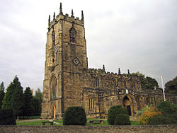
 Parish Church of St John the Baptist | |
| Location | |
| Grid reference: | SE361114 |
| Location: | 53°36’36"N, 1°27’-0"W |
| Data | |
| Population: | 10,728 (2011) |
| Post town: | Barnsley |
| Postcode: | S71 |
| Dialling code: | 01226 |
| Local Government | |
| Council: | Barnsley |
| Parliamentary constituency: |
Barnsley Central |
Royston is a suburban village in the West Riding of Yorkshire. It is found four miles north-east of Barnsley, and six mile south-east of Wakefield.[1]
The village is in Yorkshire's Staincross Wapentake.
History
The village is recorded in the Domesday Book as Rorestone:[2] the name derives from Hror's or Roarr's farm /settlement (Hrores tun).[3]
Originally a farming village, Royston joined the Industrial Revolution with the construction in the 1790s of the Barnsley Canal, and later a branch of the Midland Railway.[4] Both are now disused.
Royston had a colliery called Monckton Colliery (1878-1966).This was replaced by Royston Drift Mine. There was also, a clay works and brick works but these are all now closed, although a coke works operated until recently on the mine site processing coal brought in by road. Royston Drift Mine opened in 1975 and closed (after a relatively short period in coal mining terms) 14 years later in 1989.[5] The site is now the site of Rabbit Ings Country Park, which is now home to all five species of owls to be found in Britain.[6]
A large shirt factory with the brandname Valusta provided local employment from the 1940s through to the 1980s. Burberrys also had a factory on Midland Road
Churches
- Church of England: St John the Baptist
- Independent / Evangelical: Bethel Church
- Methodist: Royston Methodist Church
- Roman Catholic: Our Lady and St Joseph
St John the Baptist was built about the year 1234 and has a clock, a sundial, a ring of eight bells and is now grade I listed.[7][8] The church is a notable location in Royston as it is one of a few churches in the Church of England with an oriel window, and was used a navigational landmark for guiding travellers.[9]
About the village
The Trans Pennine Trail runs through Royston, along the canal bank.[10]
Outside links
References
- ↑ "Genuki: ROYSTON: Geographical and Historical information from the year 1868., Yorkshire (West Riding)" (in en). https://www.genuki.org.uk/big/eng/YKS/WRY/Royston/Royston68.
- ↑ Royston, Yorkshire in the Domesday Book
- ↑ Ekwall, Eilert, The Concise Oxford Dictionary of English Place-Names. Oxford, Oxford University Press, 4th edition, 1960. p. 395 ISBN 0198691033
- ↑ "Roydon - Rudyard | British History Online". https://www.british-history.ac.uk/topographical-dict/england/pp707-711#h3-0004.
- ↑ "Barnsley Coalfield". https://www.nmrs.org.uk/mines-map/coal-mining-in-the-british-isles/yorkshire-coalfield/barnsley/.
- ↑ "Former pit home to five owl species". BBC News. 19 Mar 2013. https://www.bbc.co.uk/news/av/uk-england-south-yorkshire-21840687/former-pit-near-barnsley-home-to-five-owl-species.
- ↑ National Heritage List 1151127: Church of St John The Baptist (Grade I listing)
- ↑ Nikolaus Pevsner: The Buildings of England: Yorkshire: The West Riding, 1959; 1967 Penguin Books ISBN isbn978-0-14-071017-5page 424
- ↑ "St John the Baptist, Church Street | Historic England" (in en). https://historicengland.org.uk/services-skills/grants/visit/st-john-the-baptist-church-street-s71-4qz/.
- ↑ "Trail Trips - Old Moor to Old Royston" (PDF). https://www.transpenninetrail.org.uk/download/9766/.