Hinderwell
| Hinderwell | |
| Yorkshire North Riding | |
|---|---|
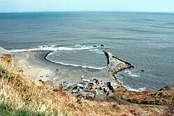
 Derelict harbour near Hinderwell | |
| Location | |
| Grid reference: | NZ792167 |
| Location: | 54°32’23"N, -0°46’36"W |
| Data | |
| Population: | 1,875 (2011) |
| Post town: | Saltburn-by-the-Sea |
| Postcode: | TS13 |
| Local Government | |
| Council: | Scarborough |
| Parliamentary constituency: |
Scarborough and Whitby |
Hinderwell is a village in the North Riding of Yorkshire, within the North York Moors National Park, about a mile from the coast on the A174 road between the towns of Loftus and Whitby.
The 2011 census recorded Hinderwell's parish population as 1,875, which count included Staithes, Port Mulgrave, Runswick Bay and Dalehouse.
History
Hinderwell appears in the Domesday Book of 1086 as Hildrewell. It is said to have got its name from Saint Hilda of Whitby, the Abbess of Whitby Abbey.[1]
Until 1958 the area was served by Staithes and Hinderwell railway stations.[2]
About the village
Hinderwell lies less than a mile inland from the Cleveland Way National Trail, along with the National Trust's Rosedale Cliffs.
Sport
- Cricket: Hinderwell Cricket Club
- Football: Hinderwell Football Club
Outside links
| ("Wikimedia Commons" has material about Hinderwell) |
References
- ↑ "Village History". https://hinderwellsite.com/home/village-history/. Retrieved 3 June 2021.
- ↑ Bairstow, Martin (2008). Railways around Whitby : Scarborough - Whitby - Saltburn, Malton - Goathland - Whitby, Esk Valley, Forge Valley and Gilling lines. Leeds: Martin Bairstow. p. 111. ISBN 978-1-871944-34-1.
