Kilpin Pike
| Kilpin Pike | |
| Yorkshire East Riding | |
|---|---|
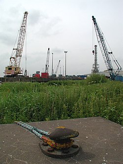
 Old moorings on the Ouse by Kilpin Pike | |
| Location | |
| Grid reference: | SE761269 |
| Location: | 53°43’59"N, -0°50’49"W |
| Data | |
| Post town: | Goole |
| Postcode: | DN14 |
| Dialling code: | 01430 |
| Local Government | |
| Council: | East Riding of Yorkshire |
| Parliamentary constituency: |
Haltemprice and Howden |
Kilpin Pike is a village in the East Riding of Yorkshire,two miles north of Goole town centre, about a mile south of Howden, and lies on the north bank of the River Ouse.
In 1823 Kilpin Pike was noted as being in the parish of Howden and the Wapentake and Liberty of Howdenshire. Occupations at the time included two shopkeepers, a butcher, a coal merchant, and the landlords of the Blue Bell and Admiral Nelson public houses.[1]
| ("Wikimedia Commons" has material about Kilpin Pike) |
References
- ↑ Baines, Edward: 'History, Directory and Gazetteer of the County of York' (1823); pages 360, 361
