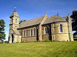
Foxholes, Yorkshire
| Foxholes | |
| Yorkshire East Riding | |
|---|---|
 St Mary's Church, Foxholes | |
| Location | |
| Grid reference: | TA011723 |
| Location: | 54°8’12"N, 0°27’10"W |
| Data | |
| Population: | 249 (2011) |
| Post town: | Driffield |
| Postcode: | YO25 |
| Local Government | |
| Council: | North Yorkshire |
| Parliamentary constituency: |
Thirsk and Malton |
Foxholes is a village in the East Riding of Yorkshire, found where the B1249 road crosses the Great Wold Valley, nine miles south of Scarborough, eleven mlies north-west of Bridlington, and seven miles north-east of Sledmere. The course of the winterbourne stream the Gypsey Race passes to the south of the village.
Parish church
The parish church, St Mary, was built in 1866 in limestone and sandstone by George Fowler Jones, in aa neo-Normal style. It is a Grade II listed building.[1]
Pevsner describes this church as: "one of the ugliest in the Riding... The north pier's are grotesque, with their undersized shafts on their over-high bases and their big square foliage capitals... Font: obstrusively Norman". He also notes several windows by Jean-Baptiste Capronnier and a 1720 cup by William Gamble.[2]
Outside links
| ("Wikimedia Commons" has material about Foxholes, Yorkshire) |
References
- ↑ National Heritage List 1174524: Church of St Mary, Foxholes (Grade II listing)
- ↑ Nikolaus Pevsner: The Buildings of England: Yorkshire: York & East Riding, 1972; 1995 Penguin Books ISBN 978-0-300-09593-7page 232
