Bennetland
| Bennetland | |
| Yorkshire East Riding | |
|---|---|
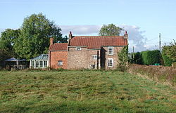
 Crumble Manor' Bennetland | |
| Location | |
| Grid reference: | SE826288 |
| Location: | 53°44’57"N, -0°44’56"W |
| Data | |
| Post town: | Brough |
| Postcode: | HU15 |
| Dialling code: | 01430 |
| Local Government | |
| Council: | East Riding of Yorkshire |
| Parliamentary constituency: |
Haltemprice and Howden |
Bennetland is a hamlet in the East Riding of Yorkshire, found 19 miles west of Hull city centre and five miles east of Howden town centre.
The village is to the is south of the M62 motorway and just to the south of the B1230 road. Bennetland lies between the Selby Line and the Hull and Doncaster Branch and is served by Gilberdyke railway station.
| ("Wikimedia Commons" has material about Bennetland) |

This Yorkshire article is a stub: help to improve Wikishire by building it up.
