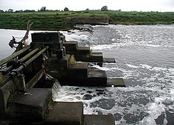
Beal, Yorkshire
| Beal | |
| Yorkshire West Riding | |
|---|---|
 Weir on the River Aire | |
| Location | |
| Grid reference: | SE530250 |
| Location: | 53°43’9"N, 1°11’50"W |
| Data | |
| Population: | 738 (2011) |
| Post town: | Goole |
| Postcode: | DN14 |
| Dialling code: | 01977 |
| Local Government | |
| Council: | North Yorkshire |
| Parliamentary constituency: |
Selby and Ainsty |
Beal is a village in the West Riding of Yorkshire, on the banks of the River Aire, three and a half miles north-east of Knottingley, eight miles south-west of Selby, and twenty-one miles south of York. The parish includes the village of Kellingley. The 2011 census recorded a population of 738.
The name "Beal" is of Old English origins and means "Nook of land in a river-bend", from the words beag halh. The village was recorded as Begale in the Domesday Book of 1086.
Kellingley Colliery, the last operating deep coal mine in the United Kingdom, was located in the parish until its closure in December 2015.
Sport
Fishing on the River Aire is controlled by Leeds and District Amalgamated Society of Anglers. The main catches are roach and bream.[1]
Outside links
| ("Wikimedia Commons" has material about Beal, Yorkshire) |
References
- ↑ "Leeds and District Amalgamated Society of Anglers". Leeds and District Amalgamated Society of Anglers. http://www.leedsdasa.co.uk/. Retrieved 28 September 2011.
