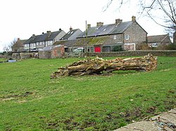
Arrathorne
| Arrathorne | |
| Yorkshire North Riding | |
|---|---|
 Cottages at Arrathorne | |
| Location | |
| Grid reference: | SE201932 |
| Location: | 54°20’5"N, 1°41’32"W |
| Data | |
| Population: | 50 (approx.) |
| Post town: | Bedale |
| Postcode: | DL8 |
| Dialling code: | 01677 |
| Local Government | |
| Council: | North Yorkshire |
Arrathorne is a hamlet in the North Riding of Yorkshire, sitting about five and a half miles south of Richmond and the same distance north-west of Bedale and east of Leyburn, in the Hang East Wapentake. The 2001 census recoded a population of 61.
The name of this village has been recorded variously as Ergthorn, Erchethorn, Erghethorn, Erethorn and Arrowthorne.[1] It means 'The Thornbush by the Shieling'.[2] Historically, the hamlet was in the Parish of Patrick Brompton.[3]
There is no pub here no is Arrathorne on a bus route. The nearest bus stop is in Hunton, just over a mile away. The nearest national rail station on the East Coast Main Line is in Northallerton eleven miles away.
There is one recorded descriptive gazetteer entry, in John Bartholomew's Gazetteer of the British Isles:
"Arrathorne, township, North-Riding Yorkshire, 5 miles NE. of Leyburn, 671 ac., pop. 62."[4]
Outside links
| ("Wikimedia Commons" has material about Arrathorne) |
References
- ↑ Place-Names
- ↑ Ekwall, Eilert, The Concise Oxford Dictionary of English Place-Names. Oxford, Oxford University Press, 4th edition, 1960. p. 12 ISBN 0198691033
- ↑ Information on Arrathorne from GENUKI
- ↑ Bartholomew, John (1887). Gazetteer of the British Isles. Bartholomew. http://www.visionofbritain.org.uk/descriptions/entry_page.jsp?text_id=1572690. Retrieved 4 February 2014.
