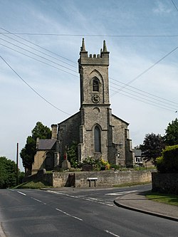
Arkendale
| Arkendale | |
| Yorkshire West Riding | |
|---|---|
 St Bartholomews Church, Arkendale | |
| Location | |
| Grid reference: | SE387610 |
| Location: | 54°2’37"N, 1°24’33"W |
| Data | |
| Population: | 394 (2011) |
| Post town: | Knaresborough |
| Postcode: | HG5 |
| Local Government | |
| Council: | Harrogate |
Arkendale is a village in the West Riding of Yorkshire, close to the lower course of the River Ure (which here forms the boundary of the North Riding). The village is six miles north-east of Harrogate town. It had a population of 278 according to the 2011 Census.
A small place, Arkendale has a pub,[1] a village hall, a church[2] and little else. Close by is another small village, Staveley.
Outside links
| ("Wikimedia Commons" has material about Arkendale) |
References
- ↑ Lemm, Elaine (24 May 2015). "Restaurant review: Blue Bell, Arkendale". The Yorkshire Post. https://www.yorkshirepost.co.uk/lifestyle/food-drink/restaurant-review-blue-bell-arkendale-1-7267929. Retrieved 9 July 2019.
- ↑ "Arkendale: St Bartholomew - A Church Near You". https://www.achurchnearyou.com/church/3163/. Retrieved 9 July 2019.
