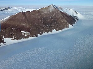
Neptune Range

The Neptune Range is a mountain range in Queen Elizabeth Land in the British Antarctic Territory, and one of the ranges which are collectively known as the Pensacola Mountains: The Neptune Range is in the central part of Pensacola Mountains. It rises to 6,480 feet at Mount Hawkes and extends from Spanley Rocks in the north to Final Rock in the south, bounded to the west by the Schmidt Hills and Williams Hills and to the east by the Washington Escarpment and associated features.
This mountain range is seventy miles long, west-south-west of the Forrestal Range in the central part of the Pensacola Mountains. It is composed of Washington Escarpment with its associated ridges, valleys and peaks, the Iroquois Plateau, and the Schmidt Hills and the Williams Hills.
Thse mountains were photographed from the air by the United States Navy, 13 January 1956, on a non-stop transcontinental flight from McMurdo Sound in New Zealand's Ross Dependency, to the Weddell Sea and back. It was named after the aircraft used for the flight; a P2V-2N Neptune (flown by Lieut. Cdr. J. H. Torbert of the United States Navy, after whom Mount Torbert is named). It was surveyed from the ground by the United States Geological Survey and rephotographed from the air by the United States Navy in 1963-64. An American refuge hut called 'Camp Neptune' was established in November 1963 at 2,018 feet on the east side of the Roderick Valley in 83°34'S 57°24'W: this is now buried in snow.
The Pensacola Mountains as a whole were mapped by United States Geological Survey in 1967 and 1968 from ground surveys and United States Navy tricamera aerial photographs taken in 1964.
Mountains
- Astro Peak (83°28’59"S, 57°0’0"W), a peak of 2,740 feet, a mile off the west end of Berquist Ridge
- Mount Dasinger (83°12’58"S, 55°2’60"W), a mountain of 4,462 feet, 6 nautical miles north-east of Neith Nunatak in the north of the Neptune Range
- Mount Torbert (83°30’0"S, 54°24’58"W), a prominent, pyramidal rock peak of 5,500 feet, midway along Torbert Escarpment in the Neptune Range
- Gillies Rock (83°6’58"S, 54°45’0"W), an isolated rock 6 nautical miles north of Mount Dasinger
Other features
- The Williams Hills
- The Schmidt Hills
Location
- Location map: 83°39’58"S, 56°0’0"W
References
- Gazetteer and Map of The British Antarctic Territory: Neptune Range