Barford St Martin
| Barford St Martin | |
| Wiltshire | |
|---|---|
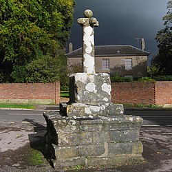
 Mediæval preaching cross near St Martin's church | |
| Location | |
| Grid reference: | SU056314 |
| Location: | 51°4’55"N, 1°55’16"W |
| Data | |
| Population: | 548 (2011) |
| Post town: | Salisbury |
| Postcode: | SP3 |
| Dialling code: | 01722 |
| Local Government | |
| Council: | Wiltshire |
| Parliamentary constituency: |
South West Wiltshire |
| Website: | Barford Parish Council |
Barford St Martin is a village in Wiltshire, about two and a half miles west of Wilton, around the junction of the A30 and the B3089, within the valley of the River Nadder, which flows through the parish.
Grovely Wood forms the northern section of the parish.
History
Prehistoric sites in the parish include the earthworks known as Ebsbury, an Iron Age settlement, field system and possible hillfort, and a Romano-British enclosed settlement, on a hilltop in the north of the parish which overlooks the valley of the River Wylye.[1] Grovely Ditch or Grim’s Ditch, a pre-Roman earthwork, runs through Grovely Wood a little further south.[2]
A small settlement called Bereford, with nine households, was recorded in the Domesday Book of 1086.[3] The ‘St Martin’ suffix, from the dedication of the church, was added by 1304 to distinguish it from Barford manor in Downton parish. Amesbury Priory acquired 78 acres in 1197, and continued to hold that manor until the Dissolution in 1539.[4]
Grovely Wood, between Barford and Great Wishford, was an extra-parochial area. By 1839, the boundary of Barford parish had moved north to include almost all of the woodland.[5]
In 1884, the hamlet of Hurdcott – on the south side of the river upstream of Barford, with population 67 in 1891 – was transferred to Barford parish from Baverstock.[6] Hurdcott has vanished as a discernible place but the name lives on in Hurdcott Home Farm and Hurdcott House (not to be confused with the Hurdcott House near Winterbourne Earls).
Greensand stone for use in buildings has long been quarried near Hurdcott, and the quarry (now operated by Lovell Stone Group) is one of the few remaining sources.[7]
Parish church

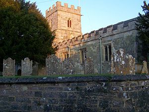
The Church of England parish church of St Martin, in the centre of the village, is a cruciform building with a crossing tower, built mostly in greensand. It stands on a man-made earth bank above the Nadder water-meadows.[8]
The 13th-century chancel is the building's oldest part, although the narrowness of the later nave implies the presence of an earlier building.[9] The nave roof is from the 16th century, and the tower (rebuilt in the 15th) carries evidence of a steeper earlier roof.[10] The north transept was rebuilt in 1841 to provide a vestry, and in the 20th century a vestibule was added at the west entrance. The church was designated as Grade I listed in 1960.[11]
Inside, monuments include a brass in the south transept to Alis Walker (died 1584) which depicts her with her eleven children.[10] 17th-century woodwork in the chancel includes wainscotting, choir stalls, the altar and reredos. There are six bells: the four heaviest were cast by William Cockey in the mid-18th century, and the two lighter bells by Mears & Stainbank in 1906.[12]
Others
An early mediæval preaching cross in the centre of the village is Grade I listed, although only the base and parts of the shaft remain.[13]
A Primitive Methodist chapel was built in 1902 to replace an earlier chapel. By 2012 it was in residential use.[14][15]
About the village
The village pub is a charming 17th-century establishment called The Barford Inn, formerly known as The Green Dragon. The Wiltshire Yeomanry dedicated a tank to this pub during the Second World War, with "The Green Dragon" on one side and "Barford St Martin" on the other.[16]
Little Orchard, on Short Lane, which began as a four-bay timber-framed hall house in the 15th century, and was altered in the 16th and 17th centuries. It is a Grade II* listed building.[17]
Other noteworthy buildings include the Manor House, across the road from the church, early 19th-century in yellow brick;[18] the former school, West Street, 1853–4; Barford House, Mount Lane, mid-18th-century in pebble-dashed brick;[19] and the Old Rectory, Groveley Road, with one 15th-century wing.[20]
Outside the village, a country house was built at Hurdcott in the 1630s,[21] and in the next century the estate came into the Powell family whose descendants included Alexander Powell (1782–1847), Member of Parliament for Downton.[22] The house was reconstructed in the 1970s.[10]
Countryside Unit at Dairy Lane
The Countryside Unit at Dairy Lane is owned by Alabaré Christian Care Centres.[23] The land used to be part of a farm, but now serves as a teaching facility for homeless and other disadvantaged people including those suffering and recovering from mental health illnesses. Skills such as woodworking, arts & crafts, and agriculture are taught there.
Outside links
| ("Wikimedia Commons" has material about Barford St Martin) |
- Barford St Martin: Wiltshire Community History
- Barford Parish Council
References
- ↑ National Heritage List 214402: Ebsbury Or Grovely Earthworks (Scheduled ancient monument entry)
- ↑ National Heritage List 1005584: Grovely Ditch (Scheduled ancient monument entry)
- ↑ St Martin Barford St Martin in the Domesday Book
- ↑ A History of the County of Wiltshire - Volume 3 pp 242-259: Houses of Benedictine nuns: Abbey, later priory, of Amesbury (Victoria County History)
- ↑ A History of the County of Wiltshire - Volume 15 pp 284-294: Great Wishford (Victoria County History)
- ↑ A History of the County of Wiltshire - Volume 4 pp 315-361: Table of population, 1801-1951 (Victoria County History)
- ↑ "Hurdcott Greenstone Quarry". https://www.lovellstonegroup.com/quarry?quarry=hurdcott-greenstone.
- ↑ Reed, Simon. "History of Barford St. Martin". https://barford.net/?page_id=83.
- ↑ "Parish Church of St. Martin, Barford St. Martin". Wiltshire Council. https://history.wiltshire.gov.uk/community/getchurch.php?id=14.
- ↑ 10.0 10.1 10.2 Nikolaus Pevsner: The Buildings of England: Wiltshire, 1963; 1975 Penguin Books ISBN 978-0-300-09659-0
- ↑ National Heritage List 1146188: Church of St Martin (Grade I listing)
- ↑ "Barford St Martin". https://dove.cccbr.org.uk/detail.php?tower=10215.
- ↑ National Heritage List 1182976: Village cross to north west of Church of St Martin (Grade I listing)
- ↑ "Barford Primitive Methodist chapel". http://www.myprimitivemethodists.org.uk/page/barford_primitive_methodist_chapel.
- ↑ "Primitive Methodist Chapel, Barford St. Martin". Wiltshire Council. https://history.wiltshire.gov.uk/community/getchurch.php?id=924.
- ↑ Sawyer. R. 2006. (Nadder) The Hobnob Press, ISBN 0-946418-53-5.
- ↑ National Heritage List 1284295: Little Orchard (Grade II* listing)
- ↑ National Heritage List 1318719: The Manor House (Grade II listing)
- ↑ National Heritage List 1284326: Barford House with Front Walls and Steps (Grade II listing)
- ↑ National Heritage List 1318753: The Old Rectory with Attached Garden Walls and Gateway (Grade II listing)
- ↑ Britton, John (1825). The Beauties of Wiltshire. London: Longman & Co.. p. 337. https://books.google.co.uk/books?id=tnZKAAAAYAAJ&pg=PA337.
- ↑ Farrell, Stephen. "POWELL, Alexander (1782-1847), of Hurdcott House, Baverstock, Wilts. and 63 Montagu Square, Mdx.". https://www.historyofparliamentonline.org/volume/1820-1832/member/powell-alexander-1782-1847.
- ↑ http://www.alabare.co.uk/
