Moor Monkton
| Moor Monkton | |
| Yorkshire West Riding | |
|---|---|
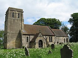
 All Saints' Church, Moor Monkton | |
| Location | |
| Grid reference: | SE507568 |
| Location: | 54°0’20"N, 1°13’36"W |
| Data | |
| Population: | 348 (2011[1]) |
| Post town: | York |
| Postcode: | YO26 |
| Local Government | |
| Council: | Harrogate |
Moor Monkton is a village and parish in the West Riding of Yorkshire, within the Ainsty wapentake. It is situated on the River Nidd, seven miles north-west of York city centre. At the 2001 Census, the population of the village was 298,[2] which had risen to 348 at the 2011 Census.[1] The population was estimated to have risen again to 370 by 2015.[3]
History
Moor Monkton is mentioned in the Domesday Book as a small settlement belonging to Richard son of Herfast.[4] The name of Moor, was added to the name Monkton to distinguish it from Nun Monkton, which is over the other side of the River Nidd. The name Monkton, which has been recorded variously as Munechatun, Monketon super Moram, Munketun, and Moore Monkton, means the town of the monks.[5][6] The village is one of the waypoints on the 44-mile Ainsty Bounds Walk that covers the boundaries of the Ainsty.[7]
Geographically, the village is at the end of a road that spurs a mile and a half north from the A59 road. The River Nidd is to the immediate north, with the River Ouse to the east. The village used to have a railway link at the Marston Moor railway station on the Harrogate Line,[8] though this station closed in 1958.[9] The nearest railway stations now are at Hammerton and Poppleton.[10] Buses call at the crossroads with the A59, south of the village, twice a day, running between Ripon and York.[11]
The parish church, dedicated to All Saints, dates in part from the 12th century. It was restored in 1879 by James Fowler, who probably added the chancel east window, and one at the south of the nave.[12][13]
Notable people
- James Hampton (1721–1778), Rector and author[14]
- John Shepherd (1765–1848), jockey[15]
- Henry Yeoman (1816–1897), Rector[16]
- Cyril Lemprière (1870–1939), head master and rugby player[17]
References
- ↑ 1.0 1.1 UK Census (2011). "Local Area Report – Moor Monkton Parish (1170217057)". Nomis. Office for National Statistics. https://www.nomisweb.co.uk/sources/census_2011_ks/report?compare=1170217057. Retrieved 14 March 2018
- ↑ UK Census (2001). "Local Area Report – Moor Monkton Parish (36UD091)". Nomis. Office for National Statistics. https://www.nomisweb.co.uk/sources/census_2001_ks/report?compare=36UD091}}
- ↑ "2015 Population Estimates Parishes". December 2016. p. 13. https://www.northyorks.gov.uk/sites/default/files/fileroot/About%20the%20council/North%20Yorkshire%20statistics/Parish_mid-year_population_estimates_2015.pdf.
- ↑ "[Moor Monkton | Domesday Book"]. https://opendomesday.org/place/SE5056/moor-monkton/.
- ↑ "Moor Monkton :: Survey of English Place-Names". http://epns.nottingham.ac.uk/browse/West+Riding+of+Yorkshire/Moor+Monkton/5328827cb47fc40c810061dd-Moor+Monkton.
- ↑ Ekwall, Eilert (1947). The concise Oxford dictionary of English place-names (3 ed.). Oxford: Clarendon Press. p. 314. OCLC 12542596.
- ↑ "Long Distance Walkers Association". https://www.ldwa.org.uk/ldp/members/show_path.php?path_name=Ainsty+Bounds+Walk.
- ↑ "History of Moor Monkton, in Harrogate and West Riding | Map and description". https://www.visionofbritain.org.uk/place/13732.
- ↑ "Disused Stations: Marston Moor Station". http://www.disused-stations.org.uk/m/marston_moor/index.shtml.
- ↑ "Moor Monkton postcodes - Postcode by address" (in en). https://postcodebyaddress.co.uk/place/moor-monkton-11930.
- ↑ "22 - York - Boroughbridge - Skelton-on-Ure - Ripon - Knaresborough – The Harrogate Bus Company – bustimes.org". https://bustimes.org/services/22-york-boroughbridge-skelton-on-ure-ripon-knaresb.
- ↑ Pevsner, Nikolaus; The Buildings of England. Yorkshire West Riding, Penguin (1959); reprinted 1967, Pevsner Architectural Guides, pp. 372, 643. ISBN 0300096623
- ↑ National Heritage List 1293654: Church of All Saints, Church Lane
- ↑ {{#invoke:citation/CS1|citation |CitationClass=encyclopaedia }} (subscription or UK public library membership required)
- ↑ Carleton, John William, ed (November 1848). "State of the Odds &c". The Sporting Review: 381. OCLC 220890872.
- ↑ Yeoman, Henry Walker. Who Was Who. 2020 (2020 online ed.). A & C Black, an imprint of Bloomsbury Publishing plc. http://www.ukwhoswho.com/view/article/oupww/whowaswho/U192510. Retrieved 4 May 2020.
- ↑ "The Moor Monkton Mercury". http://www.moormonktonmercury.co.uk/historypages/redhouse.html.
Outside links
| ("Wikimedia Commons" has material about Moor Monkton) |
- Information on Moormonkton from GENUKI
- Moor Monkton Mercury, UK individual registrant web site
- Moor Monkton Village Website, UK individual registrant web site
