Grangemill
| Grangemill | |
| Derbyshire | |
|---|---|
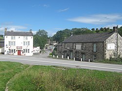
 The crossroads at Grangemill | |
| Location | |
| Grid reference: | SK243576 |
| Location: | 53°6’54"N, 1°38’18"W |
| Data | |
| Local Government | |
| Council: | Derbyshire Dales |
Grangemill is a tiny hamlet in Derbyshire, made up of a cluster of houses, a farm and a pub called the Hollybush. There is a former cheese factory in the village, and the workings of this are still on display.
Grangemill stands at the crossroads of the A5012 and B5056 roads and is at the south-eastern boundary of the Peak District National Park. The Limestone Way long-distance bridleway passes through Grangemill. The Peak District Boundary Walk also runs through the village.[1]
In the hills around Grange Mill are several quaries, in which all extract limestone from the area; the most noticeable being the Brassington Moor Quarry.
Outside links
References
- ↑ McCloy, Andrew (2017). Peak District Boundary Walk: 190 Miles Around the Edge of the National Park. Friends of the Peak District. ISBN 978-1909461536.