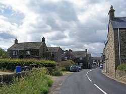
Bolsterstone
| Bolsterstone | |
| Yorkshire West Riding | |
|---|---|

| |
| Location | |
| Grid reference: | SK270967 |
| Location: | 53°28’1"N, 1°35’38"W |
| Data | |
| Post town: | Sheffield |
| Postcode: | S36 |
| Dialling code: | 0114 |
| Local Government | |
| Council: | Sheffield |
| Parliamentary constituency: |
Penistone and Stocksbridge |
Bolsterstone is a village in West Riding of Yorkshire, to the south of Stocksbridge, and eight and a half miles to the north-west of the City of Sheffield. It stands at the border of the Peak District National Park.
The 2011 census recorded Bolsterstone's population at 386.
Geography and history
Bolsterstone is just half a mile south of the town of Stocksbridge, at a height of around 980 feet above sea level on the northern side of the east–west Ewden valley, north of the Broomhead and More Hall reservoirs.
St Mary's Church was founded in 1412, and a fortified manor house ("Bolsterstone Castle") is thought to have been built by an Earl of Shrewsbury. Two buildings dating from the 16th or 17th centuries are thought to be remnants of the castle: Castle Cottages are mostly 19th-century with parts of walls dating from the earlier period;[1] Porters Lodge, also mostly 19th-century, is thought to contain elements of the castle gatehouse.[2]
A Free School was built in the village in 1686 (rebuilt 1780). Land around the village was enclosed after 1778, and St. Mary's church was rebuilt in the 1790s.
In 1802 the entire manor of Bolsterstone, over 3460 acres, was put up for sale, and acquired by James Rimington.[3]
The Castle Inn was built in 1840; Bolsterstone National School in 1851/2 and the Free School rebuilt in 1857; and a vicarage built in 1862; St Mary's Church was again rebuilt between 1872 and 1879.
About the village
The Peak District Boundary Walk runs through the village.[4]

The Bolster Stones are two standing stones which now stand in St Mary's churchyard. They were moved here having been relocated from Unsliven Bridge in Stocksbridge. It is widely believed that they give the village its name.
Outside links
| ("Wikimedia Commons" has material about Bolsterstone) |
- Bolsterstone: Stocksbridge Town Council
- Bolsterstone Genealogy Project
- Bolsterstone Community Group
References
- ↑ National Monuments Record: No. 312545 – Castle Cottage
- ↑ National Monuments Record: No. 312605 – Porters Lodge
- ↑ ''Bolsterstone for sale': The Times 4 August 1802
- ↑ McCloy, Andrew (2017). Peak District Boundary Walk: 190 Miles Around the Edge of the National Park. Friends of the Peak District. ISBN 978-1909461536.
- Bolsterstone Area, Stocksbridge & District History Society (S&DHS), http://www.stocksbridgehs.co.uk/archive/bolsterstone/
- Hunter, Joseph (1819), "The Chapelry of Bradfield – Bolsterstone", Hallamshire: The History and Topography of the Parish of Sheffield in the county of York : with Historical and Descriptive Notices of the Parishes of Ecclesfield, Hansworth, Treeton and Whiston, and of the Chapelry of Bradfield, Lackington, Hughes, Harding. Mayor, and Jones, pp. 280–281, https://books.google.com/books?id=ML8-AAAAcAAJ&pg=PA280
- Kenworthy, Joseph (1915), "Bolsterstone", The Early History Of Stocksbridge & District (15), http://www.stocksbridgehs.co.uk/collection/archive/joseph-kenworthy-handbooks/handbook_number_15_278/
