Little Cubley
| Little Cubley | |
| Derbyshire | |
|---|---|
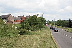
 The A515 passing Little Cubley | |
| Location | |
| Location: | SK161375 52.935416 |
| Data | |
| Population: | -2 |
| Postcode: | DE6 |
| Local Government | |
| Council: | Derbyshire Dales |
Little Cubley is a hamlet in south-western Derbyshire, along the A515 less than half a mile from its sister village, Great Cubley. These two and Cubley Common to the north are collectively known as 'Cubley'.
The hamlet is three miles east f the River Dove which marks the border of Staffordshire.