Great Cubley
| Great Cubley | |
| Derbyshire | |
|---|---|
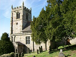
 St Andrew's Church, Cubley | |
| Location | |
| Grid reference: | SK165381 |
| Location: | 52°56’25"N, 1°45’17"W |
| Data | |
| Local Government | |
| Council: | Derbyshire Dales |
Great Cubley is a small village in south-western Derbyshire, in the open countryside six miles south of Ashbourne, on the course of an old Roman road three miles east of the River Dove which marks the border of Staffordshire.
Less than half a mile to the south-west is a hamlet, Little Cubley. These two and Cubley Common to the north are collectively known as 'Cubley'. The population of the civil parish, with Great and Little Cubley and Alkmonton, was 232 in 2011.
The parish church for the two, St Andrew's, is to the south of Great Cubley, roughly equidistant between Great and Little Cubley. It is a Grade I listed building.[1]
History
Cubley appears in the Domesday Book as Cobelei, under the title of the lands of Henry de Ferrers:
"In Cubley Siward had two carucates of land to the geld. There is land for two ploughs. There are now two ploughs in demesne and four villeins and four bordars and one slave having one plough. There is a priest and a church and one mill rendering 12 pence and eight acres of meadow and woodland pasture one league long and one league broad. In the time of King Edward worth 100 shillings now 40 shillings. Ralph holds it."
Outside links
References
- ↑ National Heritage List 1203949: Church of St Andrew (Grade I listing)