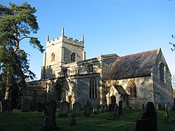
Ingoldsby
| Ingoldsby | |
| Lincolnshire | |
|---|---|
 St Bartholomew's Church, Ingoldsby | |
| Location | |
| Grid reference: | TF009300 |
| Location: | 52°51’31"N, -0°30’6"W |
| Data | |
| Population: | 254 (2001) |
| Post town: | Grantham |
| Postcode: | NG33 |
| Dialling code: | LG district=South Kesteven |
| Local Government | |
| Parliamentary constituency: |
Grantham and Stamford |
Ingoldsby is a small village in Kesteven, the south-western part of Lincolnshire, seven miles south-east of the market town of Grantham, thirty-two miles south of the county town of Lincoln, and thirty-three miles east of the City of Nottingham. The village contains approximately 121 households.
The parish church is dedicated to St Bartholomew.
Ingoldsby is situated midway between Grantham and Bourne. Adjacent villages include Great Humby, Lenton, Bitchfield and Boothby Pagnell. Close by to the east of the village is the Roman road known as King Street that ran from Bourne to near Ancaster.[1][2]
Adjacent to the village is the minor hamlet of Scotland, and Scotland House.[3] They are connected by Scotland Lane.
Outside links
| ("Wikimedia Commons" has material about Ingoldsby) |
References
- ↑ National Monuments Record: No. 1035135 – King Street
- ↑ Margary, Ivan D.: 'Roman roads in Britain' (1973) pages 232–4
- ↑ National Monuments Record: No. 505919 – Scotland House
