Bitchfield
| Bitchfield | |
| Lincolnshire | |
|---|---|
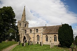
 Church of St Mary Magdalene, Bitchfield | |
| Location | |
| Grid reference: | SK988286 |
| Location: | 52°50’46"N, -0°32’1"W |
| Data | |
| Post town: | Grantham |
| Postcode: | NG33 |
| Local Government | |
| Council: | South Kesteven |
| Parliamentary constituency: |
Grantham and Stamford |
Bitchfield is a small village in Kesteven, the south-western part of Lincolnshire. It consists of two groups of buildings connected by Dark Lane, known as Bitchfield and Lower Bitchfield, collectively called Bitchfield.
The village is to be found some six miles south-east of Grantham on the B1176 road, running east and parallel to the A1.
History
Bitchfield is listed in the Domesday Book as "Billesfelt".[1] Both Bitchfield and Lower Bitchfield are sometimes described as "shrunken" rather than deserted mediæval villages. There are signs that both were more extensive at one time.[1][2]
In Bitchfield there is an earthwork known as Camp Field.[3]
Church
The parish church, in Lower Bitchfield, is dedicated to St Mary Magdalene. The church is substantially unaltered, with features of both Norman and Perpendicular architecture.[4]
Outside links
| ("Wikimedia Commons" has material about Bitchfield) |
References
- ↑ 1.0 1.1 National Monuments Record: No. 325432 – Early settlement at Bitchfield
- ↑ National Monuments Record: No. 1036263 – Early settlement at Lower Bitchfield
- ↑ Cox, J. Charles (1916) Lincolnshire p. 65; Methuen & Co. Ltd
- ↑ National Monuments Record: No. 325420 – St Mary Magdalene's Church