Bitton
| Bitton | |
| Gloucestershire | |
|---|---|
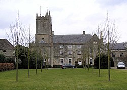
 The Grange and church in Bitton | |
| Location | |
| Grid reference: | ST682695 |
| Location: | 51°25’27"N, 2°27’30"W |
| Data | |
| Postcode: | BS30 |
| Local Government | |
Bitton is the southernmost village in Gloucestershire, to the east of the conurbation centred on Bristol, on the River Boyd and with fields running down to the River Avon, which here marks the border with Somerset.
The parish of Bitton has a population of 9,307, and apart from the village itself, includes Swineford, Upton Cheyney, Beach, Oldland Common, North Common and part of Willsbridge.
Transport
The A431 road runs through the village. Beyond Bitton the road routes north-west to Willsbridge and south-east to Kelston.
A heritage railway, the Avon Valley Railway, terminates at Bitton railway station. The National Cycle Network Bristol and Bath Railway Path runs alongside the railway.
Sport
- Cricket: Bitton Cricket Club
- Football: Bitton A.F.C.
- both play at the Recreation Ground, just west of the village.
- Running: Bitton Road Runners, a running club based in the east of Bristol
Books
- Ellacombe, Henry Thomas:
- 'History of the Manor of Bitton' (1869)
- 'History of the Parish of Bitton' (1881)
Outside links
| ("Wikimedia Commons" has material about Bitton) |
