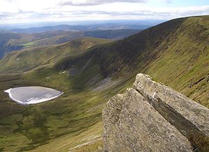
Moel Sych
| Moel Sych | |||
| Montgomeryshire, Merionethshire | |||
|---|---|---|---|
 Moel Sych and Llyn Lluncaws | |||
| Range: | Berwyn Range | ||
| Summit: | 2,726 feet SJ071323 | ||
Moel Sych is a mountain top on the ridge of the Berwyn Range, on the border of Merionethshire with Montgomeryshire. It is Montgomeryshire's county top, reaching 2,726 feet above sea level.
The name Moel Sych is Welsh, meaning "Dry Hill"; a good description of this wind-scoured summit.
Moel Sych is technically a subsidiary summit of Cadair Berwyn, whose main tops, the South Top and North Top, lie further north along the ridge. The ridge forms Merionethshire's county border with the shires to the east.
Now listed as the joint second-highest summit in the Berwyn Range along with Cadair Berwyn North Top, Moel Sych was formerly believed to be the summit in the Berwyns. However Cadair Berwyn North Top, then known just as Cadair Berwyn was measured at the same height. Later on, a fell-climber discovered a new top in between the two, which was 10 feet higher, at 2,723 feet. The Ordnance Survey agreed and the new summit is now duly marked as such, known as Cadair Berwyn South Top or in the Nuttall list as "Cadair Berwyn New Top".
Notwithstanding its demotion in the lists, Moel Sych remains the highest point in Montgomeryshire, since its two sister summits are on Merionethshire's border with Denbighshire.
The summit of Moel Sych bears a cairn, and overlooks Llyn Lluncaws in the southern corrie of the hill.[1]
Outside links
References
- ↑ Nuttall, John & Anne (1999). The Mountains of England & Wales - Volume 1: Wales (2nd edition ed.). Milnthorpe, Cumbria: Cicerone. ISBN 1-85284-304-7.