Catshill
| Catshill | |
| Worcestershire | |
|---|---|
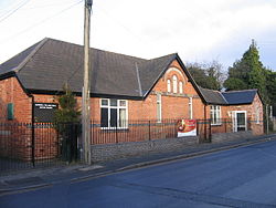
 Catshill Village Hall, on Golden Cross Lane | |
| Location | |
| Grid reference: | SO960738 |
| Location: | 52°21’44"N, 2°3’37"W |
| Data | |
| Population: | 6,858 (2011) |
| Post town: | Bromsgrove |
| Postcode: | B61 |
| Dialling code: | 01527 |
| Local Government | |
| Council: | Bromsgrove |
| Parliamentary constituency: |
Bromsgrove |
Catshill is a village in Worcestershire about two and a half miles north of Bromsgrove and ten miles south-west of Birmingham. The parish of Catshill was formed around the Turnpike Road (now the A38) in 1844.
The population of Catshill in 2011 was recorded as 6,858.
About the village
Catshill has two schools, Catshill First School and Catshill Middle School. The Middle School was built in 1939, and was converted from a Secondary Modern to a Middle School in 1970. The village has a small library, though it is not open every day.
The village also has a village hall in which many different learning activities take place, from karate to IT skills.
The village is close to access to the M5 and M42 motorways, Catshill is within commuting distance by car to both Worcester and Birmingham and as a result the population of the village has grown in recent years.
History
In 1828 a Baptist chapel was opened in Little Catshill.[1]
Catshill developed in the nineteenth century through nailmaking and by 1914 was one of the few villages in the area which produced nails.
| ("Wikimedia Commons" has material about Catshill) |
References
- ↑ Berrow's Worcester Journal, 28 August 1828
