Sydenham
| Sydenham | |
| Kent | |
|---|---|
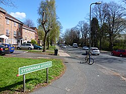
 Sydenham Avenue | |
| Location | |
| Grid reference: | TQ352714 |
| Location: | 51°25’31"N, 0°3’16"W |
| Data | |
| Population: | 28,378 ((SE26 postcode area)[1]) |
| Post town: | London |
| Postcode: | SE26 |
| Dialling code: | 020 |
| Local Government | |
| Council: | Lewisham |
| Parliamentary constituency: |
Lewisham West and Penge |
| Website: | http://sydenham.org.uk/ |
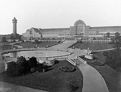
Sydenham is a suburban district of metropolitan Kent, adjacent to the border with Surrey. The junction of Rock Hill and Sydenham Hill in Upper Sydenham forms the westernmost point of Kent. The area was one of the first in southern England to have a railway station, opening 1839 by the London and Croydon Railway. Sydenham is the location where the Crystal Palace from the Great Exhibition was relocated in 1854. Today Sydenham is a diverse suburb with a population of 28,378 in 2011[1]
History
Originally known as Shippenham,[2] Sydenham began as a small settlement, a few cottages among the woods, whose inhabitants grazed their animals and collected wood. In the 1640s, springs of water in what is now Wells Park were discovered to have medicinal properties, attracting crowds of people to the area. Sydenham grew rapidly in the 19th century after the introduction of the Croydon Canal in 1809 which linked the Grand Surrey Canal to Croydon and a reservoir was constructed in Sydenham. However, the canal was never successful and closed in 1836[3] resulting in it being the first canal to be abandoned by an Act of Parliament. The London & Croydon Railway purchased the canal for £40,250 and quickly converted the alignment for a railway from London Bridge to West Croydon, opening in 1839. After the railway opened potential gas companies began to consider the Sydenham area with the Crystal Palace and District Gas Company having works at Bell Green, which continued production until 1969; a retail park now occupies most of the site.

In 1851 the Great Exhibition in Hyde Park was housed in an immense glass building, called the Crystal Palace. In 1854 the building was bought by a private company, dismantled and re-erected in Sydenham Park (now called Crystal Palace Park). Exhibitions, concerts, conferences and sporting events were held at the Crystal Palace (until it burned down in 1936), and Sydenham became a fashionable area; many new houses were built. In 1872, the Children's Hospital, Sydenham opened. It closed in 1991, its services being now part of the University Hospital Lewisham.[4]
A railway station, Upper Sydenham opened in 1884 and closed in 1954, with temporary closings in between. The station opened by the London, Chatham and Dover Railway had direct trains to Crystal Palace and London Victoria.[5] The station and the line were poorly used despite new houses being built in the area, as passengers preferred to use other stations near-by Sydenham Hill (opening in 1863), Crystal Palace (Lower Level) and Sydenham which were on more direct routes. The ill fate of the Crystal Palace in 1936 saw patronage reduced and the route finally closed in 1954.
Sydenham was attacked by enemies during the Second World War. The gas works were a target, but were never damaged. The railway which ran through Upper Sydenham station was damaged, and some homes in the area were destroyed.
Local area
Sydenham is divided into many localities:

Sydenham Hill runs alongside Dulwich and Sydenham Woods on one of the highest points of the metropolis, being 367 feet above sea level.[6] From here, the City of London skyline is visible. Sydenham Hill has an abandoned railway tunnel from the Crystal Palace and South London Junction Railway located within the Woods. Another railway tunnel (one of the longest in Britain being 1,958 meters) goes beneath on the Chatham Main Line with Sydenham Hill station at the London end serving both Sydenham Hill and the College area of Dulwich.
Upper Sydenham is also located on Sydenham Hill; the central section of Kirkdale was Sydenham's original High Street. Renamed "Kirkdale" in 1936, the area now has a small range of shops, local pubs and off-licences. Sydenham School is located on Dartmouth Road with Forest Hill Library and Forest Hill Pools alongside Thorpewood Avenue. Green-Flag-awarded Sydenham Wells Park, the location of the once-famous Springs is one of the largest parks in the area. Upper Sydenham is also the location of the Sydenham Park allotments, the Sydenham electricity sub-station and the Sydenham Hill estate.
Lower Sydenham & Bell Green is the location of Sydenham Community Library which was recently reopened by the local community after Lewisham council closed it. The Bell Green regeneration project is in its second phase with a new retail park which opened in 2013, on a site which was formally a gas works. The Bridge Leisure Centre is located on Kangley Bridge Road and Mayow Park is on the border with Forest Hill. Alongside the Hayes railway line and Lower Sydenham station, is Lower Sydenham industrial estate as well as the Beckenham and Sydenham Cricket Ground.
Commercial area
Sydenham Road also known as Sydenham High Street houses many independent stores including bookshops, off-licences and a bakery.
Community
Sydenham has a very active community, with several groups concerning the local area. Sydenham Town is the local website for the suburb, where residents can also voice their opinions in an on-line form.[7] The Sydenham Society is a Civil society formed in 1972 to represent the local community. It holds local events, works with organisations and authorities as well as campaigning for improvements to the area.[8] Green Flag and Mayor of London Award winner, Sydenham Garden, was formed in 2002. It is a charity which is involved in improving the health of residents in the boroughs of Bromley and Lewisham.[9]
Annually every summer, the Sydenham Arts Festival is held, where there are workshops, music, family activities etc.[10]
Conservation areas

Sydenham has seven Conservation Areas: Cobbs Corner, Dulwich Village (covering Crescent Wood Road),[11] Halifax Street, Sydenham Hill/Kirkdale, Sydenham Park and Sydenham Thorpes. Sydenham has the highest concentration of conservation areas in the London Borough of Lewisham[12]
Recreation
A number of parks are within the Sydenham postcode. Mayow Park, Lewisham's oldest municipal park[13] and Sydenham Wells Park[14] are both Green Flag Awarded. Other open spaces in Sydenham include Alexandra Recreation Ground,[15] Baxters Field,[16] Home Park[17] and Kirkdale Green.[18] Riverview Walk is a nature conservation area[19] which runs along the River Ravensbourne from Catford. Additionally, located along the borders of Sydenham, there are Crystal Palace Park, Dulwich Woods, Southend Park[20] and Sydenham Hill Woods.
Notable buildings and structures

- Sydenham is the home of St Bartholomew's church, (1827–1832), at the end of Lawrie Park Avenue, featured in Camille Pissarro's painting of 1871. The building was designed by Lewis Vulliamy.
- Park Court Sydenham, (1936), by Frederick Gibberd, pioneering modernist development of residential flats on the estate on Lawrie Park Road adjacent to the famous Crystal Palace Park.
- Six Pillars, (1934–35), by Berthold Lubetkin, on Crescent Wood Road, a villa strongly in the spirit of Le Corbusier with eponymous six pillars at street level.
- Cobbs Corner, takes its name from a draper’s shop at 291-307 Kirkdale run by Walter Cobb. The shop grew into a large department store catering to the gentry of the area. Interesting imposing dome where you can find the date on the building.
- 180 and 182 Kirkdale, built in the 1850s in Gothic style, with Tudor doorcases.
- 168–178 Kirkdale, three pairs of Italianate houses built around 1862. Number 174 was briefly the home of the conductor August Manns.
- Memorial to Queen Victoria (1897), baroque-style memorial celebrating Queen Victoria’s Diamond Jubilee. Restored for Queen Elizabeth II’s Silver Jubilee and designed by Alexander Hennell, a Sydenham resident and architect.
- Jews Walk, it is believed that a wealthy Jewish resident planted a row of trees to define the boundary of his walk from the Common. Numbers 2,4 and 6 are classical villas dating from the 1840s. Karl Marx's daughter Eleanor lived on Jews Walk. On 9 September 2008 a blue English Heritage plaque was placed on the house to commemorate this fact.
- Halifax Street, beautifully preserved street with houses dating from the 1840s. Of notice are in particular the closeness of the houses, the length of the street and the size of the gardens.
- The Kirkdale Building, previously the Sydenham Public Lecture Hall, was built in 1861 by Sydenham resident Henry Dawson.
Population
According to the 2011 census, the SE26 postcode area had a population of 28,378, with 13,714 males and 14,664 females.[1]
Transport

Railway stations
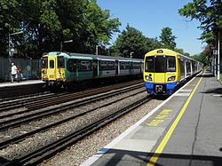
- Sydenham for London Overground and Southern services to London Bridge, London Victoria, East & West Croydon, Clapham Junction, Caterham, Shoreditch High Street and Highbury & Islington. This is the busiest station, with up to 12 trains per hour off peak and a usage of 3.3 million passengers in 2014[21]
- Sydenham Hill and Penge East stations for Southeastern services to London Victoria, Brixton, Bromley South and Orpington.
- Lower Sydenham station also is served by Southeastern but with services to London Charing Cross, London Waterloo East, London Cannon Street, London Bridge, Hayes and Lewisham.
Geography

Sydenham is approximately seven miles to the south-east of Charing Cross. It is also at the centre of many of south London's major shopping districts being three miles south of Lewisham, 3¼ miles north-west of Bromley and 3½ miles north of Croydon.
Upper Sydenham and Sydenham Hill is located on the large Norwood Ridge formed of London Claygate beds deposits; Sydenham Hill is one of the highest points in London at 367 feet. Sydenham Hill Wood is a 22-acre[22] nature reserve located west of Sydenham Hill Road, along with Dulwich and Sydenham Hill Golf course. The hill was once covered by the Great North Wood which covered all of Sydenham, Norwood, Woodside, Gipsy Hill etc. In the 19th Century it was home to the spa and health resort of Sydenham Wells.
The western parts of Sydenham, from Upper Sydenham and Forest Hill towards Crystal Palace Park is a more leafy, suburban area with some parts like the Lawrie Park and Thorpes areas being more affluent than others. Lower Sydenham at the bottom of more gentle slops being east of Upper Sydenham, south of Forest Hill and west of Bellingham. The River Pool, a five-mile tributary of the River Ravensbourne straddles the east of Lower Sydenham along the Hayes railway line.
Trivia
The Beast of Sydenham of 2005, was a large, panther-like black animal, named Arak, which had been spotted around the area, and attacked a man. The beast was said to be 6 ft in length and 3 ft in height.[23][24]
References
- ↑ Jump up to: 1.0 1.1 1.2 "Population for every postcode in England & Wales". Office of National Statistics. http://www.ons.gov.uk/ons/search/index.html?pageSize=50&sortBy=none&sortDirection=none&newquery=POSTCODE+SE26. Retrieved 18 August 2014.
- ↑ "History of Sydenham". http://www.ideal-homes.org.uk/lewisham/assets/histories/sydenham. Retrieved 29 June 2014.
- ↑ Hadfield 1969, p. 374
- ↑ http://www.ezits.myzen.co.uk/childrensydenham.html
- ↑ Butt, R.V.J. (1995). The Directory of Railway Stations. Yeovil: Patrick Stephens Ltd. p. 237. R508. ISBN 1-85260-508-1.
- ↑ Hill Bagging: Tallest Hills of London Retrieved 9 June 2013
- ↑ Sydenham Town: The Community Website For SE26 Accessed 30 July 2013
- ↑ Sydenham Society: About Us Accessed 30 July 2013
- ↑ Sydenham Garden: About Us Accessed 30 July 2013
- ↑ Sydenham Arts Festival Accessed 30 July 2013
- ↑ London Borough of Southwark: Map of Conservation Areas Accessed 30 July 2013
- ↑ LB Lewisham: Map of Lewishams' conservation areas Accessed 30 July 2013
- ↑ LB Lewisham Accessed 12 June 2013
- ↑ LB Lewisham: Sydenham Wells Park Accessed 12 June 2013
- ↑ LB Bromley: Alexandra Rec Ground Accessed 27 July 2013
- ↑ LB Lewisham: Baxters Field Accessed 12 June 2013
- ↑ LB Lewisham: Home Park Accessed 12 June 2013
- ↑ LB: Lewisham Kirkdale Green Accessed 27 July 2013
- ↑ London Borough of Lewisham: Riverview Park & River Pool Accessed 12 June 2013
- ↑ LB Lewisham: Southend Park Accessed 12 June 2013
- ↑ Station Usage, Office Of Rail Regulation Accessed 30 July 2013
- ↑ Evans, Humphrey (28 December 2003). "Secret London: Sydenham Hill - The view from the bridge". The Independent on Sunday. http://www.highbeam.com/doc/1P2-1800721.html. Retrieved 19 July 2012.
- ↑ "'Big cat' attacks man in garden". BBC News. 20 March 2005. http://news.bbc.co.uk/1/hi/england/london/4370893.stm. Retrieved 28 January 2007.
- ↑ Barkham, Patrick (25 March 2005). "Fear stalks the streets of Sydenham after resident is attacked by a black cat the size of a labrador". The Guardian (London). http://www.guardian.co.uk/uk_news/story/0,3604,1443798,00.html. Retrieved 28 January 2007.
Outside links
| ("Wikimedia Commons" has material about Sydenham) |
- Sydenhamtowncentre.com Town centre website.
- SEE3 Town Team Portas Pilot website for Sydenham/Kirkdale/Forest Hill
- Sydenham.org.uk Community website and forum.
- Sydenham Society Local community group.
- Historical images of Sydenham