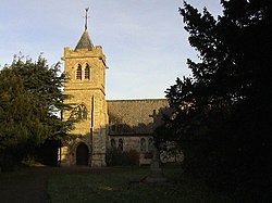
Martin, Lincolnshire
| Martin | |
| Lincolnshire | |
|---|---|
 Holy Trinity Church, Martin | |
| Location | |
| Grid reference: | TF121597 |
| Location: | 53°7’24"N, 0°19’30"W |
| Data | |
| Population: | 866 (2011) |
| Post town: | Lincoln |
| Postcode: | LN4 |
| Local Government | |
| Council: | North Kesteven |
| Parliamentary constituency: |
Sleaford and North Hykeham |
Martin is a small village in the north of Kesteven, the south-eastern part of Lincolnshire. The village stands on the western edge of the fen, through which the River Witham runs.
The village may be found about five miles west of Woodhall Spa and three miles east of Metheringham. The village of Timberland is just to the south.
The parish population at the 2011 census was 866.
About the village
Martin has a parish church, All Saints, a village shiop and a primary school. The one public house in the village is The Royal Oak. The village shop also serves as the Martin Post Office.
Extending from the eastern edge of the village is Martin Moor, a drained fen, now rich farmland and where there is also a golf course and also a koi carp farm.
A small reservoir lies 700 yards north-east of the village.
Outside links
| ("Wikimedia Commons" has material about Martin, Lincolnshire) |
