Manuden
| Manuden | |
| Essex | |
|---|---|
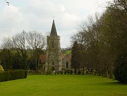
 St Mary the Virgin, Manuden | |
| Location | |
| Grid reference: | TL491266 |
| Location: | 51°55’8"N, -0°10’2"E |
| Data | |
| Population: | 677 (2011[1]) |
| Post town: | Bishop's Stortford |
| Postcode: | CM23 |
| Dialling code: | 01279 |
| Local Government | |
| Council: | Uttlesford |
| Parliamentary constituency: |
Saffron Walden |
Manuden is a village and parish in north-western Essex. It is located around 3½ miles north of Bishop's Stortford, in neighbouring Hertfordshire, and around eight miles south-west of Saffron Walden. The village has its own parish council.[2]
Manuden is mentioned in the Domesday Book of 1086 as one of the settlements within Clavering hundred.
Part of Manuden is designated as a conservation area,[3] with several listed buildings in and around the village.[4]
The local church is St Mary the Virgin. A tablet within the church commemorates the Jacobean statesman and diplomat William Wade, who spent his retirement at Battles Hall in the village, and is buried in the church.[2]
There is a primary school in the village.[5] In 2010, Manuden County Primary School topped the league table for English schools at KS2 with all pupils attaining level 5 in both English and maths.[6]
There are several active village organisations, including a local history society, junior football club and a cricket club.[2]
References
| ("Wikimedia Commons" has material about Manuden) |
- ↑ "Parish population 2011". http://www.neighbourhood.statistics.gov.uk/dissemination/LeadKeyFigures.do?a=7&b=11126290&c=CM23+1AA&d=16&e=62&g=6426438&i=1001x1003x1032x1004&m=0&r=0&s=1443353012738&enc=1. Retrieved 27 September 2015.
- ↑ 2.0 2.1 2.2 "Manuden Village Website". http://www.manuden.org.uk/. Retrieved 2009-06-08.
- ↑ "Conservation area map of Manuden". http://ggpweb.uttlesford.gov.uk:81/custom/shell/launcher.asp?dept=Planning%20Info&scriptname=plan%20apps&cpx=554685000&cpy=238362000&scale=3500. Retrieved 2009-06-17.
- ↑ "Listed buildings map of Manuden". http://ggpweb.uttlesford.gov.uk:81/custom/shell/launcher.asp?dept=Planning%20Info&scriptname=plan%20apps&cpx=554685000&cpy=238362000&scale=3500. Retrieved 2009-06-17.
- ↑ "Manuden Primary School". http://www.manuden.essex.sch.uk/. Retrieved 2009-06-08.
- ↑ "Department for Education KS2 Statistics 2010". http://www.education.gov.uk/performancetables/primary_10/england.shtml. Retrieved 2011-01-14.
This Essex article is a stub: help to improve Wikishire by building it up.