Lurigethan
| Lurigethan | |||
| County Antrim | |||
|---|---|---|---|
 Lurigethan | |||
| Range: | Antrim Hills | ||
| Summit: | 564 feet D227255 55°3’43"N, 6°4’49"W | ||
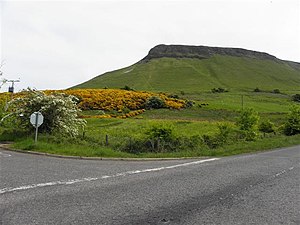
Lurigethan is a very distinctive hill overlooking the east coast of County Antrim, looking out over the North Channel. The earthwork of a promontory fort is visible on the hill, as a natural fortified position: the embankment runs in a single line across the neck of the promontory, with the precipitous slides of the hill providing the rest of the hill's defence.
Though rising to a summit at only 564 feet above sea level, Lurigethan stands out with its steep slopes on three sides overlooking the sea, and its table-topped profile is clear on the skyline from the sea and much of the coast, rising above the village of Cushendall.
The hill forms a rounded promontory in the coastline between the mouths of Glenballyemon to the north-west and Glenariff to the south-east. Behind it, to the south-west, stands Crockalough, at 1,319 feet, and Lurigethan may be seen as a summit marking the end of that mountain's long, seaward ridge.
Outside links
| ("Wikimedia Commons" has material about Lurigethan) |

