Newbiggin, Westmorland
Not to be confused with Newbiggin-on-Lune, also in Westmorland
| Newbiggin | |
| Westmorland | |
|---|---|
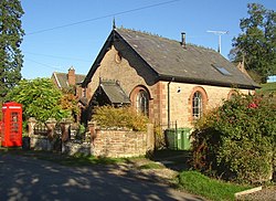
 The former Wesleyan chapel | |
| Location | |
| Grid reference: | NY628284 |
| Location: | 54°38’60"N, 2°34’38"W |
| Data | |
| Population: | 96 (2001) |
| Post town: | Penrith |
| Postcode: | CA10 |
| Dialling code: | 01768 |
| Local Government | |
| Council: | Westmorland & Furness |
| Parliamentary constituency: |
Penrith and The Border |
Newbiggin is a village on the very northern edge of Westmorland, on the south bank of the Crowdundle Beck, which marks the border with Cumberland to the north. The beck is bridged here. Newbiggin stands a mile and a half north-east of the larger village of Temple Sowerby which sits beside the River Eden.
The population of this place was recorded at just 96 in 2001 (and it was not recorded separately in 2011).
Newbiggin station opened in 1876 and closed in 1970.
| ("Wikimedia Commons" has material about Newbiggin, Westmorland) |
