Winscales
| Winscales | |
| Cumberland | |
|---|---|
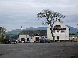
 The "Oily Johnnies" pub in Winscales | |
| Location | |
| Grid reference: | NY026260 |
| Location: | 54°37’12"N, 3°30’33"W |
| Data | |
| Postcode: | CA14 |
| Local Government | |
| Council: | Cumberland |
Winscales is a hamlet in Cumberland, just south-west of Workington. The 2011 census recorded a population of 237. The A595 road and A596 road pass through the parish – the hamlet itself is caught in the cleft between them.
The parish is bordered by Workington to the west, Great Clifton and Little Clifton to the north east, Dean to the south east, and Distington to the south.
Winscales Moor Wind Farm is in the north of the parish, and there are industrial developments. The parish council describes the parish as "primarily industrial with few residential properties".[1]
In Winscales hamlet there is a pub with the unusual name of "Oily Johnnies" also known as "Oily's". It was previously the Royal Oak but was renamed after a previous landlord who sold paraffin oil from a shed beside the pub.[2][3]
Outside links
References
- ↑ Winscale Parish Council: About us
- ↑ "Britain's Strangest Pub Names: The Legend of Oily Johnnie's". The Telegraph. 15 February 2016. http://www.telegraph.co.uk/expat/life/britains-strangest-pub-names/legend-of-oily-johnnies-in-winscales-pub-workington/. Retrieved 27 March 2017.
- ↑ "About Oily's Pub". Oily's Pub. https://oilyspub.co.uk/about.php. Retrieved 27 March 2017.