Duddon Bridge
| Duddon Bridge | |
| Cumberland | |
|---|---|
 Duddon Bridge | |
| Location | |
| Grid reference: | SD198880 |
| Location: | 54°16’55"N, 3°13’52"W |
| Data | |
| Post town: | Broughton-In-Furness |
| Postcode: | LA18, LA20 |
| Dialling code: | 01229 |
| Local Government | |
| Council: | Westmorland & Furness |
| Parliamentary constituency: |
Barrow and Furness |
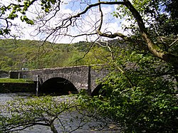
Duddon Bridge is a hamlet in Cumberland, on the west side of the River Duddon, which forms the county's border with Lancashire, at a bridge which carries the A5092 across the river here to Broughton in Furness.
The village contains the High Duddon Guest House (The Dower House) in the woodland nearby.[1]
References
| ("Wikimedia Commons" has material about Duddon Bridge) |
- ↑ Brereton, Peter (1 June 1982). Through Britain on country roads. C.N. Potter. p. 46. ISBN 978-0-517-54713-7. https://books.google.com/books?id=nN1nOeVbvScC. Retrieved 19 July 2012.
