Christchurch
| Christchurch | |
| Hampshire | |
|---|---|
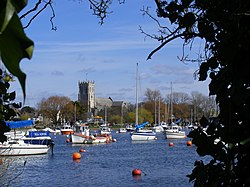 Christchurch Priory from Wick | |
| Location | |
| Grid reference: | SZ158927 |
| Location: | 50°44’4"N, 1°46’36"W |
| Data | |
| Postcode: | BH23 |
| Dialling code: | 01202 & 01425 |
| Local Government | |
| Council: | Bournemouth, Christchurch and Poole |
| Parliamentary constituency: |
Christchurch |
Christchurch is a town in Hampshire on the south coast of Great Britain. The town adjoins Bournemouth in the west and the New Forest lies to the east.
Christchurch was founded in the 7th century at the meeting of the rivers Avon and Stour which flow into Christchurch Harbour. The town was originally named Twynham but became known as Christchurch following the building of the priory in 1094.
The town developed into an important trading port and was fortified in the 9th century. Further defences were added in the 12th century with the construction of a castle which was destroyed by the Parliamentarian army during the English Civil War. During the 18th and 19th centuries smuggling flourished in Christchurch and became one of the town's most lucrative industries. The town was heavily fortified during Second World War as a precaution against an expected invasion and in 1940 an Airspeed factory was established on the town's airfield which manufactured aircraft for the Royal Air Force.
The town's harbour, beaches, nature reserves and historically important buildings have made Christchurch a popular tourist destination attracting some 1.5 million visitors a year. Bournemouth Airport, an international airport which handles approximately 800,000 passengers a year, is nearby at Hurn. The airport's industrial park contains a number of aerospace and engineering businesses.
Christchurch is a popular destination for retired folk and has one of the oldest populations in the country: 30% of residents aged over 65.
Name of the town
The town appears in the Anglo Saxon Chronicle entry of 901 as Tweoxneam (I he dative)[1] apparently from the Old English betweoxn (between) and eam (rivers).[2]
The town was known as Twynham until renamed "Christchurch" in the Middle Ages after the priory founded there in 1094.
Geography
The town abuts Bournemouth to the west and is approximately nine miles east of Poole in Dorset, and 20 miles west of Southampton. The town centre lies between the rivers Avon and Stour which flow directly into Christchurch Harbour. The borough boundaries stretch to Hurn Forest in the north encompassing Bournemouth Airport and eastwards along the coast as far as Walkford. The River Stour forms a natural boundary to the west; the estuary and harbour form the southern boundary.[3]
Christchurch Harbour

Christchurch Harbour contains large areas of salt marsh and is protected by a sandbar known as Mudeford Spit which has fine sandy beach on both sides of a walkway lined with beach huts. The harbour is protected by a natural headland (Hengistbury Head) at the start of the sandbanks, and is a special site for sand martins which nest annually in the sandy cliffs. The harbour is only accessible to shallow-draught boats drawing up to 4 feet due to the sandbars at the entrance.[4] The entrance, known as the Run, has Mudeford Quay on one side and the spit on the other. Considerable tides flow here: up to 6 knots during spring tides.[5] The harbour is a protected wildlife refuge and is home to large populations of swans, waders and other bird life. On the south side, the harbour is enclosed by Hengistbury Head which was the site of the earliest settlement here dating back to the Bronze Age.[4] The landward end of the headland has a bank and ditch known as Double Dykes, built in about 700 BC, to protect the ancient settlement.[6]
Marshes
Stanpit Marsh is a 160-acre nature reserve situated just below the meeting of the Rivers Avon and Stour. During the 18th century it was notorious for smugglers landing tobacco and rum in the narrow channels of Christchurch Harbour.[7] It contains areas of salt marsh and freshwater marsh with reed beds and is home to grazing horses, rare birds, and 14 species of rare or endangered plants.[8] It was designated as a Local Nature Reserve in 1964 and a Site of Special Scientific Interest in 1986.[9]
Landscape
To the north of Christchurch is St Catherine's Hill; the most southerly of a chain of three hills, some ridges three miles long covered in heathland and coniferous forest. The New Forest, Christchurch Priory, Hengistbury Head, Avon Valley, Christchurch Bay, The Solent and The Needles of the Isle of Wight can be seen from viewpoints on the east side of the Hill. Stour Valley way, Poole Harbour and the Isle of Purbeck can be viewed from the south-west side of the Hill. Due to its commanding views, St Catherine's Hill has been in use since prehistoric times as a look-out area and beacon and in more recent years served as a military training ground. The hill is home to protected and rare wildlife species including the Dartford warbler, nightjar, and the sand lizard.
History
Christchurch was founded in approximately AD 650 by missionaries sent to Wessex by St Birinus, the first Bishop of Dorchester (Oxfordshire). They settled on a stretch of raised land between the rivers Avon and Stour which carried people and their wares to and from settlements such as Blandford and Old Sarum.[10] The harbour became one of the most important in England in that age, as it was easily reached from Europe and boats could travel up the river Avon to Salisbury.[10][11]
In around AD 890, Alfred the Great considered Twynham to be of such strategic importance that, with the threat of invasion by the Danes, he made it a burh and defensive walls were erected around the town.[12] In 1094 a chief minister of King William II, Ranulf Flambard, then Dean of Twynham, began the building of Christchurch Priory on the site of the original mission church.[13][14] Soon after the construction of the priory the town became known as Christchurch.[15]
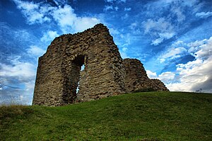
At some time in the early 12th century, a castle was built within the town.[16] Originally a wooden fort built by Richard de Redvers, first cousin to King Henry I, it was rebuilt in stone by Baldwin de Redvers to resist King Stephen during the civil war with the Empress Matilda.
The castle again saw action during the Civil War of 1642–1651 when occupied by the Parliamentarians. Christchurch changed hands a number of times: originally under Royalist control, it was captured by Sir William Waller's Parliamentary army in 1644. Lord Goring briefly retook the town in 1645 but was obliged to withdraw and returned with a larger force days later and laid siege to the castle. However, the Parliamentarians withstood the siege and maintained their hold on the town. Fearing such a powerful stronghold might once again fall into Royalist hands, Cromwell ordered that the castle be destroyed in 1652.[16][17]
Although the fishing industry thrived in Christchurch, the importance of the harbour declined as it became inaccessible to vessels of a large draught. The harbour entrance was particularly troublesome with constantly shifting sandbars. In 1665 Edward Hyde, Earl of Clarendon, bought the Lordship of the Manor of Christchurch. As part of his plans to improve trade in the town, he attempted to resolve the problems with the harbour entrance by cutting a new one through the sandspit at the foot of Hengistbury Head. However, upon completion the new entrance repeatedly silted up and in 1703 a large storm damaged a groyne which blocked the entrance entirely. Over the following 150 years alternative schemes were proposed but none was ever taken up.[18]
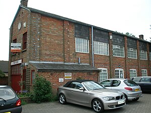
Smuggling was one of Christchurch's most lucrative trades during the 18th and 19th centuries due to easy access to neighbouring towns and the difficult harbour entrance which acted as a barrier to customs cutters.[19][20] Many townspeople were involved in this illegal trade and large quantities of wealth were accumulated.[21] In 1784 a confrontation between a gang of local smugglers and Customs and Excise officers led to the Battle of Mudeford in which a Royal Navy officer was killed and a smuggler subsequently executed.[22] Another important industry during this period was the manufacture of fusee chains for watches and clocks. In 1790, Robert Cox began to manufacture fusee chains in workshops in the High Street.[23] By 1793 Cox gained a monopoly on chain production in Britain, supplying watch, clock and chronometer makers throughout the country.[24] In 1845 William Hart opened a similar factory in Bargates. However, by 1875 the chains were no longer required due to changes in watch designs and the factories were closed.[25]
The railway came to Christchurch in 1847 although the nearest station, Christchurch Road, was at Holmsley and passengers were taken the rest of the way by omnibus.[26] In 1862 a station was built in the town close to where it stands today and was served by a branch line from Ringwood. Christchurch joined the mainline in 1883 and a third station had to be built.[27] Christchurch, and in particular Mudeford, had been enjoying a modest tourist trade since King George III had patronised the town in the 1790s but the arrival of the railways made Christchurch accessible to more potential visitors.[28][29] A power station was built in Christchurch in 1903 to power the public trams. The excess generated was sufficient to light the town and in 1940 it was added to the national grid.[30]
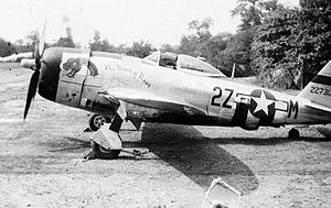
In 1930, the Fisher Aviation Company began to provide flights from fields at the eastern end of Somerford Road and by 1933 the company had flown over 19,000 passengers.[31] In 1934 they obtained permission to establish an aerodrome on the site which became known as Christchurch Airfield.[32] During the Second World War an Airspeed factory was built on the airfield and began manufacturing aircraft for the RAF and in 1944 the USAAF Ninth Air Force established a base there. A second aerodrome opened at Hurn in 1944 which became Bournemouth Airport. In 1940, with the German 6th Army encamped at Cherbourg, Christchurch was fortified against an expected invasion:[33] the construction of pillboxes, gun emplacements and tank traps in and around the town, made Christchurch an "anti-tank island".[34] Between 1941 and 1942 Donald Bailey developed the Bailey bridge at the Military Engineering Experimental Establishment at Christchurch Barracks.[35]
Much development with a large increase in housing occurred from the mid-18th century. In 1873, 300 acres of common land north of the town known as Portfield was enclosed and built upon and the town's population rapidly expanded.[36][37][38] During the 20th century further development has seen the population grown from a little over 11,000 to more than 45,000.[39] In the 1950s a large housing estate was built to the east of the town centre and in 1958 a bypass was constructed which redirected traffic using the town's high street as the main thoroughfare to and from London and Southampton.[40]
Culture
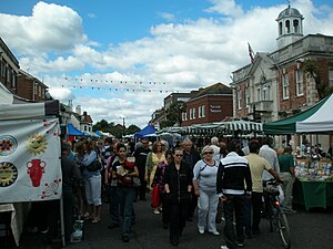
A weekly market was granted to the town by Baldwin de Redvers and the first market took place in 1149 at the junction of Castle Street and the High Street.[41] These weekly markets stopped in 1872 but resumed a century later in a car park next to the Town Hall, now the site of Saxon Square.[42] When construction of the Square began in 1983, the market was moved to a car park in Bank Close. Today it is held every Monday in the High Street which is then closed to traffic. Periodically there are food fairs and a French Market in the town.[43]
Every year since 2000 the town has held a food and wine festival during May. It includes an international food market with over 100 stalls selling food and drink, and a large marquee with a kitchen area erected in Saxon Square. Here cooking demonstrations are given, sometimes by a celebrity chef.[44] The week long festival is a community event which aims to educate people in healthy eating as well as the availability of foods. During the festival local chefs are invited into schools to demonstrate recipes; and throughout the weekend the marquee hosts a cookery workshop for 7–10 year olds.[45]
Christchurch holds an annual music festival on the first weekend in July. Originally a folk festival, the event has evolved to cater for a wider variety of tastes: clog dancing and morris dancing groups and salsa and belly dancing exhibitions have featured. Rock bands and soul groups have been included alongside the more traditional types of music. The festival's format changes annually but usually focuses around the town quay where a large marquee contains the main stage. Local bars often host smaller bands and dancing and exhibitions take place throughout the town centre.[46]
Another annual event is the regatta which has been held every year since 1909.[47] It takes place around the second week in August and involves rowing competitions on the River Stour and a funfair sited on the adjacent town quay. A carnival procession and large firework display takes place at the weekend.
The part of the quay by the priory is known as The Quomps and was conveyed to the town in 1911 by Lord Malmesbury.[48] A 19th century bandstand situated in the Quomps was an anonymous gift to the town in 1938.[49] During the summer months it is used for free open-air concerts on Saturdays, one of the most popular being "Stompin' on the Quomps", a Smooth Jazz festival.[50] On Sunday afternoons, brass bands often play there.
The town has two museums: The Red House Museum in Quay Road and the Museum of Electricity in Bargates. Once the town workhouse, the Red House contains permanent and temporary exhibitions pertaining to local history, costume, geology, natural history and archaeology. The museum grounds contain formal and informal gardens.[51][52] The Museum of Electricity is housed in the old power station in Bargates and is owned by Scottish and Southern Energy. It has educational exhibits and old machinery including a restored 1914 tram.[24]
Sights about the town
Town centre
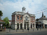
Christchurch's town centre encompasses a mixture of traditional public houses, restaurants, coffee shops, antiquated cottages and historic listed buildings.
The older part of the town dates from Saxon times and retains its Saxon street layout.[53] The Grade II listed Mayor's Parlour was built as the market hall in 1745 at the far end of the High Street but was moved to its present position in 1849.[54] It was enclosed and extended, and used as the town hall until the civic offices were built in the mid 1970s. It was restored to its former condition circa 1982 when the Saxon Square shopping precinct was built.[55]
The High Street contains two Grade II listed public houses: Ye Olde George Inne, once a coach house,[54] and The Ship Inn which has the oldest licence in Christchurch.[56] A known haunt of smugglers, the Ship Inn's history can be traced back to 1688.[57] At the end of the High Street is Church Street which contains Church Hatch, a Grade II* listed Georgian residence. Once the home of Sir Owen Tudor Burne, it was saved from demolition in 1929 by public appeal.[58] Ye Olde Eight Bells, a Grade II listed gift shop in Church Street, was once another alehouse frequented by smugglers and central to a number of local legends.[59] Close by in Castle Street is The Perfumery, a 14th-century thatched property often referred to as the old courthouse; although some local historians maintain that this was next door and long gone.[60][61]
The town centre contains three Grade I listed bridges. The Town Bridge is a 15th-century ashlar stone bridge composed of two portions separated by a narrow strip of land. The eastern portion crosses the narrower of two branches of the River Avon that pass through the town and features five low round-headed arches.[62] The western bridge features two arches and crosses the millstream which runs adjacent to the Avon. To the east of the Town Bridge on the same route from the town centre the Waterloo Bridge spans the larger branch of the Avon. Built around 1816–1817 in the mediaeval tradition with dressed Portland stone, its design incorporates five wide segmental arches, circular piers and capped cutwaters.[63] On the northern side of the bridge a modern steel pedestrian footbridge is cantilevered to the older structure.[64]
Castle
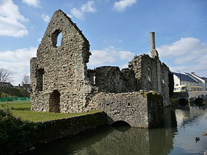
The Grade I-listed Christchurch Castle is of Norman origin and was originally of a motte and bailey construction. The castle once dominated the town but now lies in ruins and only a couple of the keep walls remain. A castle has stood in Christchurch since approximately AD 924 when Edward the Elder fortified the town with a wooden fort on a motte.[65] After the Norman conquest in 1066 the castle's defences were strengthened with a ditch and bailey surrounded by a wooden palisade. The wooden fort was replaced; at first with another wooden structure and then a stone keep which was constructed in the 12th century.[66][67]
Within the curtain wall of the castle stands the Constable's House, a Grade I-listed Norman dwelling. Much of the building's stonework remains, including a rare example of a Norman chimney (one of only five in the country) and the garderobe which extends out across the mill stream.[68]
The castle was slighted by the Parliamentary army during the English Civil War to prevent the stronghold from falling into Royalist hands.[16][17]
Priory
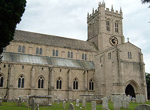
Christchurch town centre and the Harbour are overlooked by the 11th century Grade I listed Christchurch Priory. Once a monastery church, it was given to the town for use as a parish church by Henry VIII after the Dissolution of the Monasteries in 1540.[69] It is the longest parish church in England with a nave over 311 feet long.[65] The nave and transepts are Norman with heavy columns and round arches, while the lady chapel is from the 14th century and more Perpendicular in style. The great choir is even later, having been rebuilt in the 16th Century. The Priory is noted for its Miraculous Beam, which attracts pilgrims from all over the world.[65]
Within the Priory grounds stands Priory House, a Grade II listed mansion built in 1777 by Gustavus Brander.[70]
The Priory is in active use for worship and forms part of the Church of England Diocese of Winchester.
Place Mill
Place Mill is a Grade II* listed Anglo-Saxon watermill located a short distance to the south of the Priory on Christchurch Quay. It is mentioned in the Domesday Book and features a mediaeval stone base underneath red brickwork.[71] The mill belonged to the Priory but stopped working in 1908 and stood derelict until purchased by the council and restored in 1981. It is unique in that it takes water from one river (the Avon) and spills it into a second river (the Stour).[72]
A millstream is supplied from the Royalty Fisheries near to the Electricity Museum behind Bargates, and flows for nearly ½ mile to the mill between the Avon and the Priory grounds before joining the River Stour. A mediæval Grade II-listed bridge known as the Place Mill Bridge crosses the millstream nearby.[73]
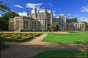
Highcliffe Castle
Situated on the cliffs at Highcliffe is Highcliffe Castle, a Grade I listed mansion.[74] The building was designed by William Donthorne for Charles Stuart, 1st Baron Stuart de Rothesay, and built between 1831 and 1835. It stands on the site of "High Cliff", a demolished Georgian mansion which belonged to Charles Stuart's grandfather John Stuart, 3rd Earl of Bute. An important remaining example of the Gothic Revival architecture, Donothorne's design incorporated French mediaeval stonework, stained glass and 18th century French panelling.[75] The house was sold in 1950 and was briefly used as a children's home and a Catholic seminary. After a devastating fire and years of neglect the castle was sold to Christchurch Borough Council in 1977 and underwent restoration.[76] Highcliffe Castle is open to the general public throughout the year and is used for weddings, private functions, exhibitions and other public events.[77]
References
Notes
- ↑ Anglo-Saxon Chronicle (Peterborough Chronicle) ({{{2}}}): þa gerad æþelwold æðeling his fæderan sunu þone ham æt Winburnan, 7 æt Tweoxnam
- ↑ Hill, Rumble (1996) p. 107 & 198.
- ↑ Taylor (1994) p. 6.
- ↑ 4.0 4.1 "Christchurch Harbour". Dorset County Council. http://www.dorsetforyou.com/389369. Retrieved 21 September 2010.
- ↑ Powell (1995) intro.
- ↑ Hoodless (2005) p. 24.
- ↑ Stannard (1999) pp. 177–178.
- ↑ "Friends of Stanpit Marsh". Friends of Stanpit Marsh. http://www.friendsofstanpitmarsh.org.uk/. Retrieved 9 August 2010.
- ↑ SSSI listing and designation for Christchurch Harbour
- ↑ 10.0 10.1 Stannard (1999) p. 1.
- ↑ Stannard (1999) p. 208.
- ↑ Stannard (1999) p. 3.
- ↑ Taylor 1994 p1
- ↑ Hodges (2003) p. 6.
- ↑ Taylor (1994) p. 1.
- ↑ 16.0 16.1 16.2 Moxey (1997) pp. 89–90.
- ↑ 17.0 17.1 Stannard (1999) pp. 135-136.
- ↑ Stannard (1999) pp. 210–211.
- ↑ Hodges (2003) p. 5.
- ↑ Stannard (1999) p. 178.
- ↑ Moxey (1997) p. 92.
- ↑ Powell (1995) pp. 46–47.
- ↑ Stannard (1999) p. 193.
- ↑ 24.0 24.1 Moxey (1997) pp. 82–83.
- ↑ Stannard (1999) p. 197.
- ↑ Taylor (1994) p. 3.
- ↑ Newman (1998) p. 34.
- ↑ Hodges (2003) p. 116.
- ↑ Newman (2009) p. 39.
- ↑ Moxey (1997) p. 82.
- ↑ Stannard (1999) pp. 226–228.
- ↑ Stannard (1999) pp. 228–229.
- ↑ Hodges (2003) pp. 51 & 90.
- ↑ Hodges (2003) pp. 88–94.
- ↑ Stannard (1999) p. 241.
- ↑ Taylor (1994) plate no.123.
- ↑ Newman (1998) p. 8 & 25.
- ↑ Newman (2009) p. 8.
- ↑ "A Vision of Britain Through Time". University of Portsmouth. 2009. http://www.visionofbritain.org.uk/data_cube_page.jsp?data_theme=T_POP&data_cube=N_TOT_POP&u_id=10056834&c_id=10001043&add=N. Retrieved 30 July 2010.
- ↑ Newman (2009) pp. 8–10.
- ↑ Hodges (2003) p. 23.
- ↑ Hodges (2003) pp. 23–24.
- ↑ "French market". Bournemouth Daily Echo. 14 June 2010. http://www.bournemouthecho.co.uk/news/districts/christchurch/8216179.French_market/. Retrieved 31 December 2010.
- ↑ "Foodie heaven - The 10th Christchurch Food and Wine Festival". Dorset Echo. 28 April 2009. http://www.dorsetecho.co.uk/archive/2009/04/28/foodanddrink/4326445.Foodie_heaven___The_10th_Christchurch_Food_and_Wine_Festival/. Retrieved 19 December 2010.
- ↑ "History". Christchurch Food and Wine Festival. 2010. http://www.christchurchfoodfest.co.uk/about.asp. Retrieved 21 September 2010.
- ↑ "Christchurch Festival information". Christchurch Festival. 2010. http://www.christchurchfestival.co.uk/show_info.php?pageID=26. Retrieved 18 August 2010.
- ↑ "The Social Seasonyear=2010". Debrett's. http://www.debretts.com/social-season/christchurch-carnival.aspx. Retrieved 18 August 2010.
- ↑ Newman (1998) p. 16.
- ↑ Hodges (2003) p. 8.
- ↑ "Stompin on the Quomps - Christchurch waterside jazz festival". Practical Boat Owner. 7 August 2010. http://www.pbo.co.uk/diary-dates/3109/stompin-on-the-quomps-christchurch-waterside-jazz-festival. Retrieved 31 December 2010.
- ↑ Stannard (1999) pp. 220–224.
- ↑ "Red House Museum". Dorset County Council. http://www.dorsetforyou.com/323095. Retrieved 19 September 2010.
- ↑ Taylor (1994) p. 2.
- ↑ 54.0 54.1 Hodges (2003) p. 17.
- ↑ Hodges (2003) pp. 13–24.
- ↑ Hodges (2003) p. 19.
- ↑ Newman (1998) p. 53.
- ↑ Newman (1998) p. 18.
- ↑ Taylor (1994) plate no.83.
- ↑ Moxey (1997) p. 90.
- ↑ Hodges (2003) p. 31.
- ↑ "Listed buildings online: Town Bridge". Heritage Gateway. http://www.heritagegateway.org.uk/Gateway/Results_Single.aspx?uid=101454&resourceID=5. Retrieved 2 November 2010.
- ↑ "Listed buildings online: Waterloo Bridge". Heritage Gateway. http://www.heritagegateway.org.uk/Gateway/Results_Single.aspx?uid=101428&resourceID=5. Retrieved 2 November 2010.
- ↑ "Waterloo Bridge New Pedestrian Walkway". Society of Chief Architects of Local Authorities. http://publicarchitecture.co.uk/project-base/projects.php?project_id=154. Retrieved 2 November 2010.
- ↑ 65.0 65.1 65.2 Moxey (1997) p. 87.
- ↑ Powell (1995) p. 33.
- ↑ Moxey (1997) p. 89.
- ↑ David Eels. "Christchurch Castle". Christchurch Local History Society. http://www.communigate.co.uk/dorset/clhs/page11.phtml. Retrieved 12 August 2010.
- ↑ Stannard (1999) p. 141.
- ↑ Hodges (2003) p. 9.
- ↑ Hinde (1996) p. 125.
- ↑ Stannard (1999) p. 4.
- ↑ "Listed buildings online: Place Mill Bridge". Heritage Gateway. http://www.heritagegateway.org.uk/Gateway/Results_Single.aspx?uid=101626&resourceID=5. Retrieved 2 November 2010.
- ↑ "Listed Buildings Online: Highcliffe Castle". Heritage Gateway. http://www.heritagegateway.org.uk/Gateway/Results_Single.aspx?uid=101633&resourceID=5. Retrieved 29 December 2010.
- ↑ Keith Miller (2 November 2002). "Making the grade: Highcliffe House". The Daily Telegraph. http://www.telegraph.co.uk/property/3308278/Making-the-grade-Highcliffe-House.html. Retrieved 29 December 2010.
- ↑ "Home: Highcliffe Castle". Highcliffe Castle. http://www.highcliffecastle.co.uk/. Retrieved 29 December 2010.
- ↑ "Visitor Information". Highcliffe Castle. http://www.highcliffecastle.co.uk/visitorinformation. Retrieved 31 October 2010.
Books
- Hill, David; Rumble, Alexander R. (1996). The defence of Wessex: the Burghal Hidage and Anglo-Saxon fortifications. Manchester University Press. ISBN 9780719032189.
- Hinde, Thomas, ed (1996). The Domesday Book: England's Heritage, Then and Now. Godalming: Coombe Books. ISBN 9781873535608.
- Hodges, Michael A (2003). Christchurch: The Golden Years. Tiverton: Dorset Books. ISBN 9781871164381.
- Hoodless, W.A (2005). Hengistbury Head: The Whole Story. Poole: Poole Historical Trust. ISBN 9781873535608.
- Moxey, Sarah (1997). Avon Valley Footpath Guide. Wellington: Halsgrove. ISBN 9781874448266.
- Newman, Sue (2009). Christchurch Through Time. Stroud: Amberley Publications. ISBN 9781848683587.
- Newman, Sue (1998). Images of England: Christchurch. Stroud: Tempus Publishing Limited. ISBN 0752410504.
- Powell, Mike (1995). Christchurch Harbour. Christchurch: Natula Publications. ISBN 1897887078.
- Stannard, Michael (1999). The Makers of Christchurch: A Thousand Year story. Christchurch: Natula Publications. ISBN 9781897887226.
- Taylor, Christine (1994). Christchurch: A Pictorial History. Chichester: Phillimore and Co. Ltd. ISBN 0850339014.
Outside links
| ("Wikimedia Commons" has material about Christchurch) |
