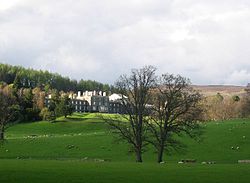
Bowhill, Selkirkshire
| Bowhill | |
| Selkirkshire | |
|---|---|
 Bowhill House | |
| Location | |
| Grid reference: | NT428278 |
| Location: | 55.541360, -2.907187 |
| Data | |
| Post town: | Selkirk |
| Postcode: | TD7 |
| Local Government | |
| Council: | Scottish Borders |
| Parliamentary constituency: |
Berwickshire, Roxburgh and Selkirk |
Bowhill is a woodland hamlet in the Ettrick Forest of Selkirkshire, in the angle between the Ettrick Water and its famed tributary, the Yarrow Water.
The village is to be found off the A708, near Selkirk. The Cross Borders Drove Road, a long-distance walking trail over the Southern Uplands, runs through Bowhill and through its woods.
Nearby places include Bowhill House, Boleside, Broadmeadows, Ettrickbridge, Kirkhope.
Outside links
- Bowhill - Borders Heritage