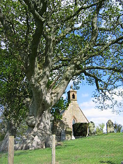
Lyne, Peeblesshire
| Lyne | |
| Peeblesshire | |
|---|---|
 The Kirk at Lyne | |
| Location | |
| Grid reference: | NT202409 |
| Location: | 55°39’19"N, 3°16’9"W |
| Data | |
| Postcode: | EH45 |
| Local Government | |
| Council: | Scottish Borders |
Lyne is a small village in Peeblesshire, four miles west of the county town, Peebles. Lyne is to be found off the A72 on the slopes north of the Lyne Water close to the point at which it falls into the River Tweed.
The Lyne Water flows below the village on its journey from the Pentland Hills to the Tweed, in an area rich with relics of past ages. At Lyne are the traces of a Roman camp, and beside the river to the west the banks and ditches of a Roman fort, while in the tongue between the rivers are standing stones.
Lyne railway station was, along with Stobo railway station, one of the nine intermediate stations of the Symington, Biggar and Broughton Railway branch line. The line has since been closed and lifted.
Dawyck Botanic Garden and Dawyck House are nearby.
Outside links
| ("Wikimedia Commons" has material about Lyne, Peeblesshire) |
