Wanborough, Wiltshire
| Wanborough | |
| Wiltshire | |
|---|---|
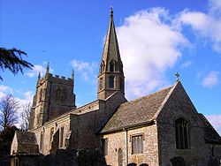
 St Andrew's, Wansborough | |
| Location | |
| Grid reference: | SU2082 |
| Location: | 51°32’38"N, 1°42’0"W |
| Data | |
| Population: | 1,762 (2001) |
| Post town: | Swindon |
| Postcode: | SN4 |
| Dialling code: | 01793 |
| Local Government | |
| Council: | Swindon |
| Parliamentary constituency: |
South Swindon |
| Website: | Wanborough Dot Info |
Wanborough is a village in Wiltshire, in the north of the county, three and a half miles southeast of Swindon town centre. The parish of Wansborough includes the hamlet of Foxhill, a mile and a half southeast of the village.
History
There was a Roman settlement here, named ‘’Durocornovium, slightly northwest of the current village, at a road junction mentioned in the Antonine Itinerary. Being the last vicus on Ermin Street before the scarp slope of the Marlborough Downs, Durocornovium was a site where horses were watered before the steep climb off the Oxfordshire plain.
Wanborough is recorded in the Anglo-Saxon Chronicle as Wodnesbeorg, which means "Woden's Hill", after the pagan god of that name. This name later became Wodnesborough before becoming Wanborough.[1][2][3][4]
Wanborough is just off the Ridgeway National Trail. Development in a strip along the road frontages characterised the village, which reached maximum development in the 4th century.[5]
Parish church
The Church of England parish church is St Andrew’s. It is unusual in having a spire at one end and a tower at the other. There are only three parish churches with this feature in the United Kingdom; the others are at nearby Purton, Wiltshire and at Ormskirk in Lancashire.
About the village
The village has a small post office and shop. The village has five public houses: The Brewers Arms; The New Calley Arms;[6] The Cross Keys; The Harrow;[7] and The Plough. There was also a sixth pub called The Black Horse which closed down early in 2012
Foxhill had one public house, The Shepherd's Rest which has re-opened as a restaurant serving Indian cuisine and renamed "The Burj".[8]
There is a monthly farmers market in the village hall on the 3rd Saturday of every month, except August where is replaced by the Wanborough Show[9]
Wanborough has a primary school[10]
Redlands Airfield[11] is a base for microlight aviation and skydiving parachute training.
Outside links
| ("Wikimedia Commons" has material about Wanborough, Wiltshire) |
References
- ↑ Jaques, Tony. 'Dictionary of Battles And Sieges: A Guide to 8,500 Battles from Antiquity Through the Twenty-first Century'. Greenwood Publishing Group, 2006. ISBN 0-313-33536-2, ISBN 978-0-313-33536-5. Length: 1432 page
- ↑ Duignan, William Henry. 'Notes on Staffordshire Place Names'. H. Frowde, 1902. Length: 178 pages
- ↑ Johnston, James Brown. 'The Place-names of England and Wales. E.P. Dutton and Co., 1916, Princeton University. Length: 532 pages
- ↑ Green, John Richard. 'A Short History of the English People'. Macmillan, London 1901. Digital: http://www.archive.org/details/shorthistoryofen01greeuoft
- ↑ Stillwell, ed. Princeton Encyclopedia of Classical Sites, s.v. "Durocornovium"
- ↑ The New Calley Arms
- ↑ The Harrow Inn
- ↑ The Burj
- ↑ Wanborough Show
- ↑ Wanborough Primary School
- ↑ Redlands Airfield
