Tisbury
| Tisbury | |
| Wiltshire | |
|---|---|
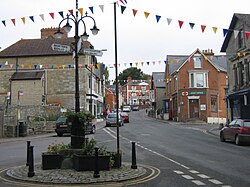
 The Square, looking up at High Street | |
| Location | |
| Grid reference: | ST944291 |
| Location: | 51°4’0"N, 2°4’49"W |
| Data | |
| Population: | 2,056 (2001) |
| Post town: | Salisbury |
| Postcode: | SP3 |
| Dialling code: | 01747 |
| Local Government | |
| Council: | Salisbury |
| Parliamentary constituency: |
Salisbury |
Tisbury is a large village in Wiltshire, approximately 13 miles west of Salisbury.
With a population at the 2001 census of 2,056, it is an important local centre for communities around the upper River Nadder and Vale of Wardour. It is the largest settlement within the Cranborne Chase and West Wiltshire Downs Area of Outstanding Natural Beauty.
Transport
Tisbury railway station is on the West of England Main Line, placing its residents within commuting distance of London. The village is 2.5 miles from the A303 trunk road linking Andover with the West Country.
History

The village has some historical significance. As in much of the Wiltshire Downs, there is evidence of Bronze Age settlement and traces of a probable henge monument with some evidence of settlement 3–4000 years ago. To the southeast of the village there is a quite large hill fort, known as Castle Ditches.[1]

In the Anglo-period the manor of Tisbury came into the possession of Shaftesbury Abbey across the county border in Dorset. The administration centre was the monastic grange, still called Abbey Grange Place Farm. Its 15th-century thatched tithe barn, a Grade I listed building,[2] bears the largest thatched roof in Britain.
The old Wardour Castle lies approximately 2.5 miles to the southwest of Tisbury.
The village's 13th-century prosperity came from the quarries that produced stone for the building of Salisbury Cathedral, and from the wool that supported a local cloth industry. The village suffered a serious setback with the Black Death in the mid-14th century but slowly recovered.
Thomas Mayhew (31 March 1593 – 25 March 1682) who in 1642 established the first British settlement at Martha's Vineyard in North America, was born in Tisbury.
On John Speede's map of Wiltshire of 1611, the village's name is recorded as Tilburye: the cartographer or the engraver clearly having mistaken a long s for an l.
Sir Matthew Arundell of Wardour Castle, a great landowner and a cousin of Queen Elizabeth, was entombed in the Tisbury parish church, St John's, in 1598. The churchyard also holds the graves of Rudyard Kipling's parents, John Lockwood Kipling and Alice Kipling (née MacDonald), and contains what is reckoned to be the second oldest tree in Great Britain, a large yew tree which is believed to be around 4,000 years old.[3]
According to one source, "After a long and distinguished artistic career in India, the Kiplings moved to a residence along Hindon Lane which they renamed 'The Gables'. Their famous son visited them here and, whilst working on his novel Kim, his father (his illustrator) used the drawings of one of the pupils from Tisbury Boys' School as the model for the main character."[4] As of early 2013, The Gables, with five bedrooms and an adjoining cricket pitch, was for sale at a price of £950,000.
Television and arts
Some scenes in the 2009 film Morris: A Life with Bells On were filmed in Tisbury, including at the Tisbury Sports Centre[5] and other scenes were filmed at the nearby Compasses Inn at Lower Chicksgrove.
Tisbury has recently become home to The Ashley Wood Festival of the Acoustic Arts which is hosted at Ashley Wood Farm.
Outside links
- Victoria County History information on Tisbury parish]
- Pictures of Tisbury and the area on Geograph.co.uk
References
- ↑ Tisbury, Wiltshire
- ↑ National Heritage List 1318824: Tithe Barn at Place Farm
- ↑ Tisbury and Old Wardour Castle at visitwiltshire.co.uk
- ↑ "A Victorian family house with excellent accommodation, gardens and land," Strutt & Parker, accessed 11 March 2013.
- ↑ Mike Turner (13 February 2009). "With bells on! Salisbury basketball players' role in Morris dancing movie". Salisbury Journal. http://www.salisburyjournal.co.uk/sport/sportgeneral/4125257.With_bells_on__Salisbury_basketball_players__role_in_Morris_dancing_movie/. Retrieved 5 July 2010.
- Jackson, Ralph (Autumn 1983). "The Lockwood Kiplings at Tisbury, Wiltshire". The Hatcher Review 2: 278–284.