Blackrod
| Blackrod | |
| Lancashire | |
|---|---|
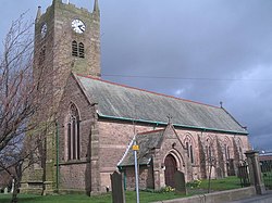
 St Katharine, Blackrod | |
| Location | |
| Grid reference: | SD615105 |
| Location: | 53°35’23"N, 2°34’51"W |
| Data | |
| Population: | 5,300 (2001) |
| Post town: | Bolton |
| Postcode: | BL6 |
| Dialling code: | 01942/01204 |
| Local Government | |
| Council: | Bolton |
| Parliamentary constituency: |
Bolton West |
Blackrod is a village in the heart of Lancashire, 4 miles north of Wigan and 7 miles west of Bolton. The 2001 Census recorded a population of 5,300.[1]
Blackrod was once a coal mining village.
History
The name Blackrod derives from the Old English, blæc rodu, meaning a "dark clearing". The first mention of the village dates to 1189, when it was recorded as Blacherode. It was recorded as Blakerodein in 1200, and Blacrode in 1220.[2] Another suggestion is that the suffix is the Old English rod meaning "cross" (rood).[3]
Blackrod is reputed to be the site of a Roman station[4] and they built a fort on the northern side of the town, on what is now a residential area called Castle Croft.[5] The A6 road is built along the course of a Roman road passes below the hill on which the town is built.
In the first half of the 12th century the manor of Blackrod was held by William Peverel, but was confiscated by the king and in 1190 it was granted to Hugh le Norreys. In 1212 Hugh de Blackrod was tenant. In 1223 Hugh Norreys became lord of Blackrod and the manor descended through his family. Mabel Norris heiress of Blackrod and Haigh married Roger de Bradshaw and the manor remained with the Bradshaws until the 16th century.[2]
Arley Hall was an estate in the west of the township held by William le Walsh in 1393 and later by Standishes and Norrises.[2] The hall was a moated manor house and is now the site of Wigan Golf Course.
After the Industrial Revolution the main industry of the town was coal mining and there was a brickworks. In 1869 the collieries operating in Blackrod included Anderton Hall, Dootson Vauze, Park Hall, Rigby Hill, Marklands and Blackrod.[6] The Scot Lane Colliery employed 628 men underground and 122 surface workers in 1923, it closed in 1932.[7] There were formerly bleachworks, a calico-printing works[4] and weaving mill was built in 1906.
About the village
Blackrod is situated on hilly ground near the River Douglas, west of the West Pennine Moors, and covers 2,344 acres.[4] It lies west of the M61 motorway, which divides it from Horwich. In the west is Arley, now the site of a golf course and to the south is Scot Lane.
Between Blackrod, Lostock and Horwich is Red Moss, a 116.6 acre) Site of Special Scientific Interest (SSSI) which was designated in 1995 because of its biological interest. The site is managed by a wildlife trust.[8]
Churches
The earliest mention of a chapel in Blackrod was in 1338 when Dame Mabel de Bradshagh endowed a chantry priest to say divine service and mass in the chapel of St Catherine.[2] The present church, dedicated to St Katharine of Alexandria, is of Norman design but Elizabethan work can still be seen, but the parish church was enlarged in 1776, galleries added in 1837, the roof renewed in 1894, the chancel rebuilt in 1905 and nave in 1911. During this time the spelling has changed to Catherine, and now the current Katharine. There are six bells in the west tower, cast in 1776, renewed in 1922, and the clock was illuminated in 1947.
Outside links
| ("Wikimedia Commons" has material about Blackrod) |
References
- ↑ Neighbourhood Statistics - Blackrod CP (Parish). URL accessed 18 May 2007.
- ↑ 2.0 2.1 2.2 2.3 A History of the County of Lancaster: Volume 5 – pages 299–303
- ↑ Billington, W.D. (1982). From Affetside to Yarrow : Bolton place names and their history, Ross Anderson Publications (ISBN 0-86360-003-4).
- ↑ 4.0 4.1 4.2 A Topographical Dictionary of England, pages 58–62, 1848}}
- ↑ Bolton.org.uk - Blackrod. URL accessed May 4, 2007.
- ↑ Collieries at work in1869, Coal Mining History Resource Centre, http://freepages.genealogy.rootsweb.ancestry.com/~cmhrc/lom69nel.htm, retrieved 26 November 2010
- ↑ Scot Lane Colliery - Durham Mining Museum
- ↑ Red Moss lnr, Lancashire Wildlife Trust, http://www.lancswt.org.uk/index.php/red-moss-lnr.php, retrieved 25 November 2010
- Kay, Margaret M. (1966), The History of Rivington and Blackrod Grammar School (2nd ed.), Manchester: Manchester University Press
