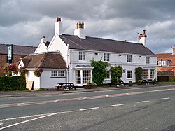
Long Marston, Yorkshire
| Long Marston | |
| Yorkshire West Riding | |
|---|---|
 The Sun Inn, Long Maston | |
| Location | |
| Grid reference: | SE501511 |
| Location: | 53°57’13"N, 1°14’12"W |
| Data | |
| Post town: | York |
| Postcode: | YO26 |
| Dialling code: | 01904 |
| Local Government | |
| Council: | Harrogate |
| Parliamentary constituency: |
Selby and Ainsty |
Long Marston is a village in the West Riding of Yorkshire. It is outside the heavily industrialised zones of the West Riding, standing in the broad, drained meadowland of Marston Moor between the River Nidd and River Wharf. It is to be found on the B1224 road from Wetherby to York. Long Marston is 7 miles west of York.
The Battle of Marston Moor, one of the major battles of the Civil War, was fought just west of the village and there is a monument to the battle on the Tockwith Road to the north of the village.
About the village
The village has a junior school, a public house (The Sun Inn) and until 2008 had a Methodist church, which has since closed in recent years.
The village has a Village Hall (off Butt Hedge on Angram Road) and Playing Fields, which is also home to the two cricket teams which compete in the Wetherby Cricket league
Hutton Wandesley
The small hamlet of Hutton Wandesley is directly adjacent to the village. For all intents and purposes Hutton Wandesley forms part of Long Marston.
Outside links
| ("Wikimedia Commons" has material about Long Marston, Yorkshire) |
