Ashford, Kent
| Ashford | |
| Kent | |
|---|---|
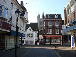 North Street, Ashford | |
| Location | |
| Grid reference: | TR005425 |
| Location: | 51°8’47"N, 0°52’3"E |
| Data | |
| Population: | 58,936 (2001) |
| Post town: | Ashford |
| Postcode: | TN23, TN24, TN25 |
| Dialling code: | 01233 |
| Local Government | |
| Council: | Ashford |
| Parliamentary constituency: |
Ashford |
Ashford is a town in Kent, which has become a key ttransport hub for Kent and for all of southeast Britain, which has caused growth in the size of the town. Ashford stands on the River Great Stour, and on the M20 motorway and on the South Eastern Main Line and High Speed 1 railways. Its agricultural market is one of the most important in the county.
In 2005, Ashford was voted the fourth best place to live in the United Kingdom.[1] The criteria for such a judgment seem somewhat opaque.
Name of the town
The name "Ashford" is a pretty common English placename, coming usually from the Old English æsc ford, menaing just that: "Ash (tree) ford".
Ashford is listed in the Domesday Book with additional middle syllables, as "Essetesford". No form like *æscet is known in Old English and suggestions such as æsctires ford ("Battle-glory Ford") are little more than romantic fancy without more to back them. Philpot believed Essetesford stood for "ash tree growing near a ford" (æsc æt þe forde), while Lampard, a 16th century local historian, suggested that it meant "a ford over the river Eshe or Eshet", which was the old name for the tributary of the River Stour between Lenham and Ashford.
Geography
Ashford lies in a valley at the meeting of the Great Stour and East Stour rivers, where the Great Stour turns northwards to go through the Stour Gap in the North Downs towards Canterbury, Sandwich, and the English Channel. To the south lies the Weald.
The town today
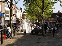
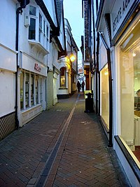
Essentially a modern town, little is left of the old Ashford town centre, apart from some mediæval half-timbered buildings in Middle Row and around the churchyard in the town centre. A number of old buildings were removed to make way for the controversial ring road around the centre, built in the early 1970s. Three modern shopping centres are located in the town: Park Mall, County Square, and the new Designer Outlet. Bank Street and High Street are traffic-free shopping thoroughfares.
The original town of Ashford, in common with most such towns, has outgrown its original size and has combined with smaller villages in a conurbation. These villages include Bockhanger, Kennington, Sevington, Singleton, and Willesborough. In addition, housing estates have been built in the open spaces amongst Bybrook, Godinton, Kingsnorth, Park Farm, and Stanhope.
The increase in the town's commercial importance, as well as its strategic location, is witnessed by the number of industry, business, and retail parks in the town. These include Waterbrook, a 183-acre site for manufacturing, storage and distribution with a freight clearance facility; Eureka Science and Business Park, including manufacturing sites and prestige office complexes; the 141-acre Orbital Park; the Ashford Designer Outlet shopping centre, which has won a design award; and fourteen other business parks and industrial estates. There is also a factory of Premier Foods UK, making soup.
History
As a market town, Ashford has for centuries been a local centre for surrounding villages. When the railway came in the nineteenth century, Ashford stood at the centre of five lines; the Ashford to Ramsgate (via Canterbury West) line, Swanley to Ashford (via Maidstone East) Line, South Eastern Main Line, Kent Coast Line and the Marshlink Line. With the opening of Ashford International station, feeding passenger traffic to and from the Channel Tunel, Ashford is now an important European communications centre, with lines running between London and Europe through the tunnel.
The town lies on the eastern edge of the ancient forest of the Weald, known in Anglo-Saxon days as "Andredsweald" or "Anderida", and which once stretched from here and as far west as Hampshire.
It is likely that the town originates from an original settlement established in 893 by inhabitants escaping a Viking raid on the nearby ancient village of Great Chart (recorded as Seleberhtes Cert in 762). Old habitation was always hereabouts though, for a Roman road passed through here from the iron making area to Canterbury.
Ashford is listed in the Domesday Book of 1086 as "Essetesford", and had a church, two mills and a value of 150 shillings. The manor was owned by Hugh de Montford, Constable of England at the time. Writer Philpot believed Essetesford stood for "ash trees growing near a ford", while Lampard, a 16th century local historian, suggested that it meant "a ford over the river Eshe or Eshet", which was the old name for the tributary of the River Stour between Lenham and Ashford.
The closeness of the town to London has always made Kent a strong influence on the capital, and vice versa. By the end of the 16th century Jack Cade (of Cade’s Rebellion) was said by William Shakespeare in Henry VI, Part II to be from Ashford. The play includes an Ashford butcher called "Dick" who looks forward to removing officialdom after the rebellion and says: first thing, let’s kill all the lawyers.
Ashford’s importance as a growing agricultural and market town was confirmed in 1243 when it was incorporated, and by the end of the 16th century it had risen to become an important market town, primarily for livestock. The market was held in the High Street until 1856 when local farmers and businessmen relocated to Elwick Road and formed a market company that claims to be the oldest surviving registered company in England and Wales. There is still a regular street market in the town, although the market company has relocated outside the town and is used by some 5,000 farmers.[2]
Parts of the parish church date from the 13th century but was substantially restored in the 15th century with many alterations since. In 1638 a free grammar school was founded here, it was built on the churchyard’s west side, and remained there until 1846, now used as a museum.
During Second World War Ashford's importance as a transportation and railway hub and its location between the Continent and London made it a target for bombing by the Luftwaffe.
The Joint Services School of Intelligence was based at Templer Barracks in Ashford, until the barracks were decommissioned in 1997 and then demolished to make way for High Speed 1.[3]
Transport
Ashford is well known as one of England's great transport hubs, overshadowing the likes of Ebbsfleet in the South-East of England.
Roads
Ashford was one of the towns in Kent to become a hub when the roads were turnpiked in the second half of the 18th century.[4] Those roads later became the A20 road from London to the Channel ports; and the A28 which runs from Margate, through Canterbury onto Tenterden and Hastings. The A251 links the town with Faversham and the M2.
The A292 Ashford Ring Road was created in the 1970s around the town centre in an attempt to relieve congestion along the previous main thoroughfare in the town centre, the narrow East Hill. The Ring Road has recently been converted to two-way traffic again, to minimise the "race track" feel and help bring the isolated town centre back into the rest of the area.[5] There are plans for a fast public transport link between the town centre and the suburbs and main amenities, called "SMARTLINK".
Motorway
Junctions 9 and 10 on the M20 motorway serve the town. Additionally The A2070 links the town with Romney Marsh and Rye.
"Operation Stack" on the M20, usually implemented in response to strikes by Frenchmen in Calais, used to bring Ashford to a halt several times each year until the new service station off of Junction 11 on the M20 was built.
Railway
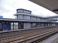
The railway came to Ashford when the South Eastern Railway's London to Dover main line opened between 1842 and 1844, and the company established its locomotive works here. The railway community had its own shops, schools, pubs and bathhouse, and much of the area retains the look of a "railway town". The works closed in 1981.
Ashford became a junction when the line to Margate was opened in 1846; in 1851 today's Marshlink Line to Hastings was opened, and on 1 July 1884 the final connection, from Maidstone, was made.
The Ashford International station opened with the Channel Tunnel in 1994. It now serves Eurostar trains on High Speed 1, with trains to London, Lille and Paris and connections to the rest of Europe.
In November 2007 direct services to Brussels were withdrawn and the frequency of trains to Paris was reduced to three a day when Ebbsfleet International railway station opened. Local firms, residents and politicians were amongst those seeking a less drastic change in the Eurostar timetable. With the introduction of domestic train services in 2009 along the new High Speed One line to St Pancras (London) and Stratford, Essex, travel time from Ashford to London was reduced from 83 to about 37 minutes.[6] A limited preview service for the high speed trains began in July 2009, and the full service launched on 14 December 2009.
Air
Ashford was formerly served by Lympne Airport, commercial services ceased in 1974. The airfield at Lydd was designated London Ashford Airport, though 17 miles from Ashford, and has regular flights to Le Touquet, France by Lydd Air. Gatwick Airport, the nearest fully international airport is 58 miles from Ashford.
Bicycle
The National Cycle Network, a network of cycle routes across the United Kingdom, includes two routes through Ashford:
- NCR 17 - Rochester - Maidstone - Ashford - Hythe
- NCR 18 - Canterbury - Ashford - Tenterden - Tunbridge Wells.
The Stour Valley Walk also follows the main river, connecting with other such long distance footpaths in this part of Kent, including the North Downs Way.
Culture
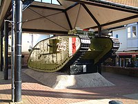
Within the town there are few tourist attractions. Ashford Borough Museum stands here. It does have Godinton House and Gardens[7] and the Willesborough Windmill.
A First World War Mk IV tank built in Lincoln was presented to the town on 1 July 1919 to thank the townsfolk for their war efforts. It is displayed in the town centre.[8][9]
The Ashford Green Corridor is a linear park alongside the two main rivers through the town.
Media
- Radio:
- KMFM Ashford
- AHBS Community Radio
- Newspapers:
- The Kentish Express
- yourashford
- The Ashford Herald
Sport
- Football: Ashford Town Football Club, formed around 1880 as Ashford United
- Hockey: Ashford Hockey Club, formed in 1898.
- Rugby: Ashford Rugby Club
- Swimming: Ashford Town Swimming Club
- Archery: Ashford Archers
- Athletics etc:
- The Julie Rose Stadium in Willesborough
- Ashford Athletics Club (based in the Julie Rose Stadium)
- Ashford Judo Club
Outside links
- MyAshford.com - the guide to Ashford and the surrounding area
- Ashford's Future website - the company leading Ashford's regeneration plans
- History website includes maps and Photographs
- Ashford Chamber of Commerce website
- Ashford Borough Council website
- kentish express - Local news and events from the Ashford area
- yourashford - Weekly news paper website
References
- ↑ [1]
- ↑ Goashford.com
- ↑ Kings College, London
- ↑ The Rural Landscape of Kent, S.G.McRae & C.P.Burnham, Wye College,1973
- ↑ Kent County Council
- ↑ http://www.dft.gov.uk/pgr/rail/pi/ctrl/backgroundinformationonthech341 Department for Transport
- ↑ Godinton House and Gardens
- ↑ http://www.ashford.towntalk.co.uk/events/d/3795/ Article on the 90th Anniversary of the WW1 Ashford tank.
- ↑ History of Ashford