Porthdinllaen
| Porthdinllaen | |
| Caernarfonshire | |
|---|---|
 Porthdinllaen and the Bay | |
| Location | |
| Grid reference: | SH275413 |
| Location: | 52.941708) -4.568048 |
| Data | |
| Local Government | |
| Council: | Gwynedd |
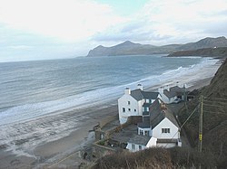
Porthdinllaen is a tiny fishing hamlet, barely that, in Caernarfonshire on the leeward edge of a narrow, rocky spit ending in the headland of Porthdinllaen Head, jutting out from the northern coast of the Lleyn peninsula. Porthdinllaen a little up the coast from Morfa Nefyn and its name also designates the gentle, sandy bay to the east formed by that headland.
The hamlet of Porthdinllaen is a single short street of fishermen’s houses, along with the boats, net and equipment that go with them, a haven of peace when the boats are at sea and full of lively activity when the work is landward. North of the hamlet is a lifeboat station.
The Lleyn Coastal Path runs up to Porthdinllaen Head and back.
A remarkable thing about this little place is that it came close to being transformed into a major port. In the early nineteenth century, Parliament determined to build a new port to service ships from Dublin, specifically because the union with Ireland brought members to Parliament from Ireland and they required an easy crossing. The competition was between Porthdinllaen and Holyhead on Holy Island, Anglesey; the latter had a disadvantage in that those arriving there still had to cross to Anglesey and then to cross the hazardous waters of the Menai Strait, but Holyhead was eventually chosen, and the Menai was bridged. In the peace of an evening it is hard to imagine the quiet bay being churned up and filled with concrete, cranes and industrial port facilities, and it had a fortunate escape.