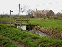
Kirkland, East Cumberland
| Kirkland | |
| Cumberland | |
|---|---|
 Kirkland Church in January 2008 | |
| Location | |
| Grid reference: | NY647324 |
| Location: | 54°41’10"N, 2°32’49"W |
| Data | |
| Post town: | Penrith |
| Postcode: | CA10 |
| Dialling code: | 01768 |
| Local Government | |
| Council: | Westmorland & Furness |
| Parliamentary constituency: |
Penrith and The Border |
Kirkland is a tiny village in Cumberland, at the edge of the Pennines and close to no town nor any other village of any size. Blencarn is a mile to the south-west and Skirwith two miles to the west. Also a mile to the south is the Crowdundle Beck, which marks the county border with Westmorland.
The fells rise immediately to the east: overlooking the village is Kirkland Fell, a prominence in the western slope of Cross Fell (2,930 feet). A long-distance walking route, A Pennine Journey, touches Kirkland on its route north from Milburn, Westmorland to Cross Fell. The Pennine Way is a little further up the fell slope, crossing over the summit of Cross Fell.
On the hill slope above the village are a small series of man-made terraces known as the Hanging Walls of Mark Anthony. They are mediæval "lynchets" or cultivation terraces (and today a scheduled ancient monument).[1].
Outside links
| ("Wikimedia Commons" has material about Eden Kirkland, East Cumberland) |
References
- ↑ National Heritage List 1007135: The Hanging Walls of Mark Anthony
