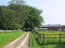
Towthorpe, East Riding: Difference between revisions
Jump to navigation
Jump to search
Created page with "{{Infobox town |name=Towthorpe |county=Yorkshire |riding=East |picture=Towthorpe.jpg |picture caption=Towthorpe |os grid ref=SE901629 |latitude=54.054187 |longitude=-0.624789..." |
m RB moved page Towthorpe, Yorkshire to Towthorpe, East Riding |
(No difference)
| |
Latest revision as of 19:31, 16 November 2023
| Towthorpe | |
| Yorkshire East Riding | |
|---|---|
 Towthorpe | |
| Location | |
| Grid reference: | SE901629 |
| Location: | 54°3’15"N, -0°37’29"W |
| Data | |
| Post town: | Driffield |
| Postcode: | YO25 |
| Dialling code: | 01377 |
| Local Government | |
| Council: | East Riding of Yorkshire |
| Parliamentary constituency: |
East Yorkshire |
Towthorpe is a hamlet in the East Riding of Yorkshire, sitting in the Yorkshire Wolds just north of the B1248 road, approximately eight miles north-west of Driffield and two miles south-west of Sledmere.
Outside links
| ("Wikimedia Commons" has material about Towthorpe, East Riding) |
References
- Gazetteer — A–Z of Towns Villages and Hamlets. East Riding of Yorkshire Council. 2006. p. 11.
