Difference between revisions of "Tollingham"
From Wikishire
(Created page with "{{Infobox town |name=Tollingham |county=Yorkshire |riding=East |picture=Industrial Estate, Tollingham - geograph.org.uk - 4514478.jpg |picture caption=Industrial Estate, Tolli...") |
(No difference)
|
Latest revision as of 19:17, 16 November 2023
| Tollingham | |
| Yorkshire East Riding | |
|---|---|
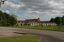
 Industrial Estate, Tollingham | |
| Location | |
| Grid reference: | SE832356 |
| Location: | 53°48’38"N, 0°44’12"W |
| Data | |
| Post town: | York |
| Postcode: | YO43 |
| Dialling code: | 01430 |
| Local Government | |
| Council: | East Riding of Yorkshire |
| Parliamentary constituency: |
Haltemprice and Howden |
Tollingham is a hamlet in the East Riding of Yorkshire, two mlies south-east of its nearest village, Holme-on-Spalding-Moor and seven miles north-east of its nearest market town, Howden. The hamlet stands to the west of the Market Weighton Canal.
| ("Wikimedia Commons" has material about Tollingham) |
References
- Gazetteer — A–Z of Towns Villages and Hamlets. East Riding of Yorkshire Council. 2006. p. 11.