Difference between revisions of "Broom, Yorkshire"
From Wikishire
(Created page with "{{Infobox town |name=Broom |county=Yorkshire |riding=West |picture=Broom - Broom Lane (B6410) Junction with Broom Road (A6021) - geograph.org.uk - 956823.jpg |picture caption=...") |
(No difference)
|
Latest revision as of 06:17, 18 October 2023
| Broom | |
| Yorkshire West Riding | |
|---|---|
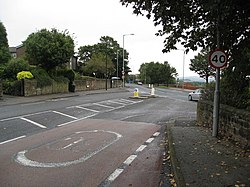
 Road junction in Broom | |
| Location | |
| Grid reference: | SK444915 |
| Location: | 53°25’12"N, 1°19’48"W |
| Data | |
| Population: | 900 |
| Post town: | Rotherham |
| Postcode: | S60 |
| Dialling code: | 01709 |
| Local Government | |
| Council: | Rotherham |
| Parliamentary constituency: |
Rotherham |
Broom (historically sometimes spelled "Broome") is a village in the West Riding of Yorkshire, in the old parish of Whiston about a mile south-east of Rotherham.
The village sits on top of a former Roman fortification and was the site of a Saxon trading town. The village currently has a population of 900. The town supports three pubs, a football club, Broom United, and numerous other small businesses.