Difference between revisions of "Painsthorpe"
From Wikishire
(Created page with "{{Infobox town |name=Painsthorpe |county=Yorkshire |riding=East |picture=Painsthorpe.jpg |picture caption=Painsthorpe, looking west |os grid ref=SE814583 |latitude=54.014381...") |
(No difference)
|
Revision as of 18:14, 5 October 2023
| Painsthorpe | |
| Yorkshire East Riding | |
|---|---|
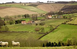
 Painsthorpe, looking west | |
| Location | |
| Grid reference: | SE814583 |
| Location: | 54°-0’52"N, 0°45’29"W |
| Data | |
| Post town: | York |
| Postcode: | YO41 |
| Dialling code: | 01759 |
| Local Government | |
| Council: | East Riding of Yorkshire |
| Parliamentary constituency: |
East Yorkshire |
Painsthorpe is a hamlet in the East Riding of Yorkshire, found about a mile east of the village of Kirby Underdale. This is a remote area: the nearest town is the small town of Pocklington some five miles to the south.
This hamlet was the site of Painsthorpe Abbey, an Anglican Benedictine monastery.
Outside links
| ("Wikimedia Commons" has material about Painsthorpe) |
- Painsthorpe in the Domesday Book
References
- Gazetteer — A–Z of Towns Villages and Hamlets. East Riding of Yorkshire Council. 2006. p. 9.