Difference between revisions of "Little Hatfield"
From Wikishire
(Created page with "{{Infobox town |name=Little Hatfield |county=Yorkshire |riding=East |picture=Little Hatfield.jpg |picture caption=Little Hatfield |os grid ref=TA173432 |latitude=53.872273 |lo...") |
(No difference)
|
Latest revision as of 18:17, 4 September 2023
| Little Hatfield | |
| Yorkshire East Riding | |
|---|---|
 Little Hatfield | |
| Location | |
| Grid reference: | TA173432 |
| Location: | 53°52’20"N, 0°12’58"W |
| Data | |
| Post town: | Hull |
| Postcode: | HU11 |
| Dialling code: | 01964 |
| Local Government | |
| Council: | East Riding of Yorkshire |
| Parliamentary constituency: |
Beverley and Holderness |
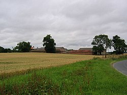
Little Hatfield is a small hamlet in the East Riding of Yorkshire, on Holderness, about three miles south-west of Hornsea town centre, and less than a mile west of Great Hatfield.
In 1823 Little Hatfield was noted as being in the parish of Sigglesthorne, and in the Wapentake and Liberty of Holderness. The population at the time was 25, which included a farmer.[1]
Little Hatfield was served from 1864 to 1964 by Sigglesthorne railway station on the Hull and Hornsea Railway.[2]
Outside links
| ("Wikimedia Commons" has material about Little Hatfield) |
References
- ↑ Baines, Edward: 'History, Directory and Gazetteer of the County of York' (1823); page 214
- ↑ Butt, R. V. J. (1995). The Directory of Railway Stations: details every public and private passenger station, halt, platform and stopping place, past and present (1st ed.). Sparkford: Patrick Stephens Ltd. ISBN 978-1-85260-508-7. OCLC 60251199.
- Gazetteer — A–Z of Towns Villages and Hamlets. East Riding of Yorkshire Council. 2006. p. 7.