Difference between revisions of "Laverton, Yorkshire"
From Wikishire
(Created page with "{{Infobox town |name=Laverton |county=Yorkshire |riding=West |picture=Laverton Cottages.jpg |picture caption=Cottages in Laverton |os grid ref= SE228733 |latitude=54.1551659 |...") |
(No difference)
|
Latest revision as of 22:48, 29 August 2023
| Laverton | |
| Yorkshire West Riding | |
|---|---|
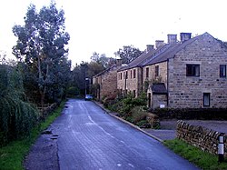
 Cottages in Laverton | |
| Location | |
| Grid reference: | SE228733 |
| Location: | 54°9’19"N, 1°39’6"W |
| Data | |
| Local Government | |
| Council: | North Yorkshire |
Laverton is a village in the West Riding of Yorkshire, about seven miles est of Ripon. The population of this parish as taken at the 2011 census was 260.
The River Laver, from which the settlement derives its name, flows through the village.[1] The parish includes the area of Dallowgill west of the village of Laverton.
Historically Laverton was a township in the ancient parish of Kirkby Malzeard.[2] It became a separate civil parish in 1866.
Outside links
| ("Wikimedia Commons" has material about Laverton, Yorkshire) |
References
- ↑ Ekwall, Eilert, The Concise Oxford Dictionary of English Place-Names. Oxford, Oxford University Press, 4th edition, 1960. p. 290 ISBN 0198691033
- ↑ "Laverton Tn/CP through time | Census tables with data for the Parish-level Unit". http://www.visionofbritain.org.uk/unit_page.jsp?u_id=10442539#. Retrieved 17 February 2019.